347g, Stretford Road, Manchester, M15 4AY
About 347g
347g is a three-bedroom mid-terrace house in Manchester (M15 4AY). It has a recorded floor area of 68 m² (around 732 sq ft), construction records dating it to 1996-2002 and council tax band B. At 68 m² this is the 61st smallest of 70 units on EPC record in the building, where floor areas span 43–81 m². The building's EPC ratings span E to B across 70 units on file. Other recorded features include a balcony. The latest certificate (December 2020) shows a C (score 79), near the top of the C band. The recommended improvements would push it to B (score 82). Main heating runs on electricity.
Untraded for 23 years, with the last transfer in May 2003. Across 1998–2003, sale prices on this property compounded at 12.1% per year. Today's modelled estimate of £187,000 sits 87.9% above the 2003 sale of £99,500. At 68 m² it's 25.9% larger than the typical home in the postcode (54 m² median across 69 EPCs).
What this property has
Inside
- Bedrooms3
Outside
- ParkingAllocated
- BalconyYes
Everything you need to know about 347g
The true value, the hidden risks and the full sale history, in one report.
30-day money-back guarantee

The data behind every report


Energy performance
EPC Rating
Planning history
347g has no planning applications on record.
Notable planning nearby
3applications of note in the surrounding area
We flagged 1 thing worth checking at 347g
Independent checks surfaced things a buyer would want to understand before offering. The report explains each one in full, with the underlying data and what to ask.
- Larger development activity nearby
30-day money-back guarantee
Sales history & valuation
347g's estimated value is more than triple its earliest registered sale price (1998).
£187,000
Modelled from EPC, postcode comparables and a sale-price growth of 12.1% per year over 5 years.
£99,500
Growth on file: 12.1% per year over 5 years.
Sales timeline
20 May 2003Most recent
£99,500
+68.9%over 4 years15 October 1998
£58,900
Median price across the last 5 sales in M15 4AY: £180,000 (2025–2023).
Nearby sales in M15 4AY
357b, Stretford Road, Manchester, M15 4AY
Sold Sept 2025
£192,000353c, Stretford Road, Manchester, M15 4AY
Sold Mar 2025
£165,000347d, Stretford Road, Manchester, M15 4AY
Sold Jan 2024
£198,700347f, Stretford Road, Manchester, M15 4AY
Sold Nov 2023
£180,000359d, Stretford Road, Manchester, M15 4AY
Sold Sept 2023
£147,500
Versus other Stretford Road homes
347g outperforms the street on floor area by a wide margin.
Price per m²
£1,463
Street avg £1,897
Floor Area
68 m²
Street avg 57 m²
Habitable Rooms
4 rooms
Street avg 3 rooms
CO₂ Emissions
2.5 t/year
Street avg 2.4 t/year
Everything you need to know about 347g
The true value, the hidden risks and the full sale history, in one report.
30-day money-back guarantee
The data behind every report
Similar properties nearby
The neighbourhood at a glance
Crime
1/mo
Steady year-on-year across the wider district.
Nearest stop
0.1 km
Mallow Street — bus stop.
Closest school
0.3 km
Rolls Crescent Primary School. 44 schools nearby.
Go deeper on the local area
The full report breaks down crime, transport links, schools and air quality in depth.
Road noise across the postcode
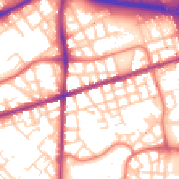
Daytime· 07:00 – 23:00
56.6dB

Night-time· 23:00 – 07:00
47.0dB