7 Chertsey Close, Luton, LU2 9JD
About 7 Chertsey Close
7 Chertsey Close is a three-bedroom mid-terrace house in Luton (LU2 9JD). It has a recorded floor area of 87 m² (around 936 sq ft), construction records dating it to 1950-1966 and council tax band C. The latest certificate (July 2012) shows a D (score 56), a step below the typical UK home. The recommended improvements would lift it to B (score 81), a 2-band jump. The latest certificate is from July 2012, so improvements made since then won't be reflected.
Across 1995–2012, sale prices on this property compounded at 7.7% per year. Today's modelled estimate of £278,000 sits 79.4% above the 2012 sale of £155,000. 13 years since the last transfer (December 2012). Across the public record there are 6 sales, relatively high churn for a single property.
What this property has
Inside
- Bedrooms3
Everything you need to know about 7 Chertsey Close
The true value, the hidden risks and the full sale history, in one report.
30-day money-back guarantee

The data behind every report


Energy performance
Recommended upgrades on file would lift this property by multiple EPC bands.
EPC Expired
This certificate is over 10 years old and is no longer valid.Expired 01 Jul 2022
EPC Rating
Planning history
7 Chertsey Close has no planning applications on record.
Notable planning nearby
1applications of note in the surrounding area
Sales history & valuation
Sale price has grown by over 3x since 1995.
£278,000
Modelled from EPC, postcode comparables and a sale-price growth of 7.7% per year over 17 years.
£155,000
Growth on file: 7.7% per year over 17 years.
Sales timeline
10 December 2012Most recent
£155,000
+0.6%over 6 years27 March 2006
£154,000
+18.5%over 3 years26 February 2003
£130,000
+122.2%over 4 years15 June 1998
£58,500
+30.0%over 2 years29 March 1996
£45,000
+2.3%8 December 1995
£44,000
Median price across the last 5 sales in LU2 9JD: £246,000 (2025–2021).
Versus other Chertsey Close homes
Floor Area for 7 Chertsey Close lags the street by a wide margin.
Price per m²
£1,782
Street avg £2,083
Floor Area
87 m²
Street avg 101 m²
Habitable Rooms
4 rooms
Street avg 6 rooms
CO₂ Emissions
4.6 t/year
Street avg 3.9 t/year
Everything you need to know about 7 Chertsey Close
The true value, the hidden risks and the full sale history, in one report.
30-day money-back guarantee
The data behind every report
Similar properties nearby
The neighbourhood at a glance
Crime
6/mo
Steady year-on-year across the wider district.
Nearest stop
0.1 km
Chertsey Close — bus stop.
Closest school
0.7 km
Queen Elizabeth School. 18 schools nearby.
Go deeper on the local area
The full report breaks down crime, transport links, schools and air quality in depth.
Road noise across the postcode
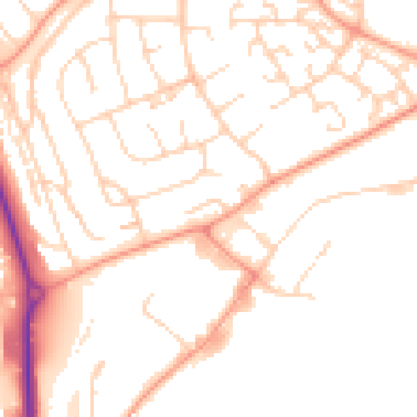
Daytime· 07:00 – 23:00
50.3dB

Night-time· 23:00 – 07:00
39.6dB