15 Chertsey Close, Luton, LU2 9JD
About 15 Chertsey Close
15 Chertsey Close is a three-bedroom mid-terrace house in Luton (LU2 9JD). It has a recorded floor area of 88 m² (around 951 sq ft), construction records dating it to 1950-1966 and council tax band C. The latest certificate (April 2009) shows an E (score 52), well below the UK norm with real room to improve. The recommended improvements would lift it to C (score 78), a 2-band jump. The latest certificate is from April 2009, so improvements made since then won't be reflected.
It hasn't traded since January 2008, a hold of 18 years that's notably long for the area. That sale landed at the peak of the pre-credit-crunch market, which is a useful reference point when interpreting the price. Today's modelled estimate of £287,000 sits 73.9% above the 2008 sale of £165,000. On a £-per-square-foot basis, the last sale (£174/sq ft) was about 15.6% above the typical sold price in the postcode. It lags the bulk of the postcode on energy efficiency (less efficient than 84% of similar EPCs).
What this property has
Inside
- Bedrooms3
Outside
- Private gardenYes
- GarageYes
Building
- Central heatingYes
Everything you need to know about 15 Chertsey Close
The true value, the hidden risks and the full sale history, in one report.
30-day money-back guarantee

The data behind every report


Energy performance
Recommended upgrades on file would lift this property by multiple EPC bands.
EPC Expired
This certificate is over 10 years old and is no longer valid.Expired 22 Apr 2019
EPC Rating
Planning history
15 Chertsey Close has no planning applications on record.
Notable planning nearby
1applications of note in the surrounding area
Sales history & valuation
The latest sale landed at the peak of the pre-credit-crunch market — a high-water reference point.
£287,000
Modelled from EPC, postcode comparables.
£165,000
Recorded with HM Land Registry.
Sales timeline
25 January 2008Most recent
£165,000
Median price across the last 5 sales in LU2 9JD: £246,000 (2025–2021).
Versus other Chertsey Close homes
On epc rating, 15 Chertsey Close runs well behind the street norm.
Price per m²
£1,868
Street avg £2,080
Floor Area
88 m²
Street avg 101 m²
Habitable Rooms
4 rooms
Street avg 6 rooms
CO₂ Emissions
5.7 t/year
Street avg 3.8 t/year
Everything you need to know about 15 Chertsey Close
The true value, the hidden risks and the full sale history, in one report.
30-day money-back guarantee
The data behind every report
Similar properties nearby
The neighbourhood at a glance
Crime
6/mo
Steady year-on-year across the wider district.
Nearest stop
0.1 km
Chertsey Close — bus stop.
Closest school
0.7 km
Queen Elizabeth School. 18 schools nearby.
Go deeper on the local area
The full report breaks down crime, transport links, schools and air quality in depth.
Road noise across the postcode
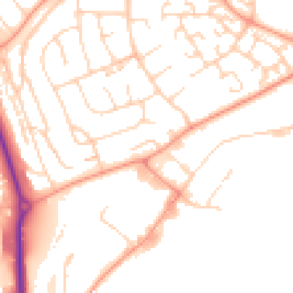
Daytime· 07:00 – 23:00
50.3dB

Night-time· 23:00 – 07:00
39.6dB