The Crest, Moreton Road North, Luton, LU2 9DP
About The Crest
The Crest is a detached house in Luton (LU2 9DP). It has a recorded floor area of 100 m² (around 1074 sq ft), construction records dating it to 1967-1975 and council tax band D. The latest certificate (October 2010) shows an E (score 51), well below the UK norm with real room to improve. The recommended improvements would push it to D (score 61). The latest certificate is from October 2010, so improvements made since then won't be reflected.
At 100 m² the property is well over the postcode median (56 m² across 27 EPCs), placing it in the larger end of the local stock. On energy efficiency it sits in the bottom 10% of properties in this postcode — significant headroom for improvement. Across 2012–2013, sale prices on this property compounded at 38.8% per year. Today's modelled estimate of £374,000 sits 66.2% above the 2013 sale of £225,000. On a £-per-square-foot basis, the last sale (£210/sq ft) was about 33% above the typical sold price in the postcode. 5 planning records sit against the property, 3 approved, 2 refused. Past consents include an extension, a garage conversion and a loft conversion, meaningful when judging how the property has evolved. Last sold in June 2013, so it's been off the market for around 13 years.
Everything you need to know about The Crest
The true value, the hidden risks and the full sale history, in one report.
30-day money-back guarantee

The data behind every report


Energy performance
The Crest sits at the bottom of the postcode for energy efficiency — meaningful headroom to improve.
EPC Expired
This certificate is over 10 years old and is no longer valid.Expired 14 Oct 2020
EPC Rating
Planning history
The Crest has been extended on multiple sides of the property across separate planning applications.
- Jun 2020Garage ConversionFullIn report
Extension: Single storey · Rear of property
Erection of single storey rear extension and garage conversion.
Extension- Documents
- 11 docs on file
- Reference
- 20/00467/FULHH
- Nov 2019ExtensionOutlineIn report
Extension: Single storey · Rear of property
Request for a determination as to whether prior approval is required under Part 1 Class A of the Town and Country Planning (General Permitted Development) Order 2015 - Single storey rear extension (detached). Depth 8m, Maximum height of extension 2.5m, Height to eaves 2.5m.
- Documents
- 4 docs on file
- Reference
- 19/01303/RES
We flagged 1 thing worth checking at The Crest
Independent checks surfaced things a buyer would want to understand before offering. The report explains each one in full, with the underlying data and what to ask.
- Recent ownership pattern worth a look
30-day money-back guarantee
Sales history & valuation
The Crest changed hands twice within eighteen months — unusual for the area.
£374,000
Modelled from EPC, postcode comparables and a sale-price growth of 38.8% per year over 1 year.
£225,000
Growth on file: 38.8% per year over 1 year.
Sales timeline
26 June 2013Most recent
£225,000
+55.2%over 1 year22 February 2012
£145,000
Median price across the last 5 sales in LU2 9DP: £180,000 (2022–2018).
Nearby sales in LU2 9DP
Versus other Moreton Road North homes
EPC Rating for The Crest lags the street by a wide margin.
Price per m²
£2,256
Street avg £2,642
Floor Area
100 m²
Street avg 89 m²
Habitable Rooms
4 rooms
Street avg 4 rooms
CO₂ Emissions
6.3 t/year
Street avg 3.8 t/year
Everything you need to know about The Crest
The true value, the hidden risks and the full sale history, in one report.
30-day money-back guarantee
The data behind every report
Similar properties nearby
The neighbourhood at a glance
Crime
6/mo
Steady year-on-year across the wider district.
Nearest stop
0.3 km
Deep Denes — bus stop.
Closest school
0.2 km
Ramridge Primary School. 30 schools nearby.
Go deeper on the local area
The full report breaks down crime, transport links, schools and air quality in depth.
Road noise across the postcode
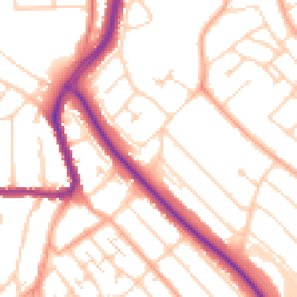
Daytime· 07:00 – 23:00
52.2dB

Night-time· 23:00 – 07:00
41.8dB