18 Arnold Close, Luton, LU2 9AW
About 18 Arnold Close
18 Arnold Close is a three-bedroom semi-detached house in Luton (LU2 9AW). It has a recorded floor area of 80 m² (around 861 sq ft), construction records dating it to 1950-1966 and council tax band C. The latest certificate (February 2022) shows a C (score 69), just inside the C band. The recommended improvements would push it to B (score 85). Our model identifies extension potential, subject to local planning policy. The home occupies a cul-de-sac position.
Its energy rating outperforms most of the postcode (better than 75% of similar EPCs). Across 2002–2022, sale prices on this property compounded at 4.8% per year. Today's modelled estimate of £368,000 is 15% above the 2022 sale price. On a £-per-square-foot basis, the last sale (£372/sq ft) was about 126.2% above the typical sold price in the postcode. Last sale on file: £320,000 in July 2022. That sale was during the post-pandemic price surge, when transactions cleared materially above pre-2020 trend.
What this property has
Inside
- Bedrooms3
Outside
- Private gardenYes
- GarageYes
- Cul-de-sacYes
Building
- Extension potentialPossible
Everything you need to know about 18 Arnold Close
The true value, the hidden risks and the full sale history, in one report.
30-day money-back guarantee

The data behind every report


Energy performance
EPC Rating
Planning history
18 Arnold Close has no planning applications on record.
Notable planning nearby
1applications of note in the surrounding area
Sales history & valuation
18 Arnold Close has more than doubled in price since the earliest registered sale in 2002.
£368,000
Modelled from EPC, postcode comparables and a sale-price growth of 4.8% per year over 20 years.
£320,000
Growth on file: 4.8% per year over 20 years.
Sales timeline
7 July 2022Most recent
£320,000
+156.0%over 20 years25 April 2002
£125,000
Median price across the last 5 sales in LU2 9AW: £240,000 (2021–2006).
Versus other Arnold Close homes
On price per m², 18 Arnold Close stands well clear of the street.
Price per m²
£4,000
Street avg £2,630
Floor Area
80 m²
Street avg 103 m²
Habitable Rooms
5 rooms
Street avg 6 rooms
CO₂ Emissions
3.0 t/year
Street avg 5.9 t/year
Everything you need to know about 18 Arnold Close
The true value, the hidden risks and the full sale history, in one report.
30-day money-back guarantee
The data behind every report
Similar properties nearby
The neighbourhood at a glance
Crime
6/mo
Steady year-on-year across the wider district.
Nearest stop
0.2 km
Birchen Grove — bus stop.
Closest school
0.2 km
Sacred Heart Catholic Primary School. 30 schools nearby.
Go deeper on the local area
The full report breaks down crime, transport links, schools and air quality in depth.
Road noise across the postcode
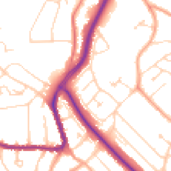
Daytime· 07:00 – 23:00
51.5dB

Night-time· 23:00 – 07:00
41.6dB