52a, High Town Road, Luton, LU2 0DF
About 52a
52a is a two-bedroom mid-terrace house in Luton (LU2 0DF). It has a recorded floor area of 85 m² (around 915 sq ft), construction records dating it to 1900-1929 and council tax band A. At 85 m² this is the 8th smallest of 9 units on EPC record in the building, where floor areas span 32–85 m². The building's EPC ratings span E to D, with this unit at the top. The latest certificate (November 2020) shows a D (score 56), a step below the typical UK home. The recommended improvements would push it to C (score 76).
Held since June 1997 — that's 29 years off the open market, well above the local norm. Only one transfer is on record with HM Land Registry, suggesting it has stayed in the same hands for a long time. At 85 m² the property is well over the postcode median (44 m² across 8 EPCs), placing it in the larger end of the local stock. Today's modelled estimate of £224,000 sits 1393.3% above the 1997 sale of £15,000. On a £-per-square-foot basis, the last sale (£16/sq ft) was about 88.5% below the postcode norm.
What this property has
Inside
- Bedrooms2
Building
- RefurbishedYes
Everything you need to know about 52a
The true value, the hidden risks and the full sale history, in one report.
30-day money-back guarantee

The data behind every report


Energy performance
EPC Rating
Planning history
52a has no planning applications on record.
Notable planning nearby
30applications of note in the surrounding area
We flagged 2 things worth checking at 52a
Independent checks surfaced things a buyer would want to understand before offering. The report explains each one in full, with the underlying data and what to ask.
- Signs of HMO activity in the area
- Larger development activity nearby
30-day money-back guarantee
Sales history & valuation
52a's modelled value sits at over four times its earliest registered sale price (1997).
£224,000
Modelled from EPC, postcode comparables.
£15,000
Recorded with HM Land Registry.
Sales timeline
23 June 1997Most recent
£15,000
Median price across the last 5 sales in LU2 0DF: £102,000 (2025–2002).
Versus other High Town Road homes
52a is notably below the street on price per m².
Price per m²
£176
Street avg £3,126
Floor Area
85 m²
Street avg 49 m²
Habitable Rooms
3 rooms
Street avg 3 rooms
CO₂ Emissions
5.1 t/year
Street avg 3.8 t/year
Everything you need to know about 52a
The true value, the hidden risks and the full sale history, in one report.
30-day money-back guarantee
The data behind every report
Similar properties nearby
1 Elmfield Court, Bloomfield Avenue
LU2 0PX
1 Buchanan Court, Buchanan Drive
LU2 0SA
1 Armstrong Road
LU2 0FU
1 Edward Street
LU2 0NF
1 Blaydon Road
LU2 0RP
1 Ella Court, High Town Road
LU2 0BP
1 Durham Road
LU2 0RB
1 Abbey Drive
LU2 0LG
The neighbourhood at a glance
Rail-style transport is unusually close for this postcode.
Crime
6/mo
Steady year-on-year across the wider district.
Nearest stop
0.1 km
St Matthews Church — bus stop.
Closest school
0.2 km
St Matthew's Primary School. 36 schools nearby.
Go deeper on the local area
The full report breaks down crime, transport links, schools and air quality in depth.
Road noise across the postcode
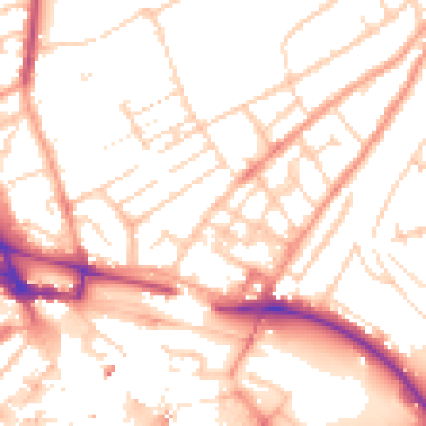
Daytime· 07:00 – 23:00
52.9dB

Night-time· 23:00 – 07:00
41.9dB