15 Boundary Road, Litherland, Liverpool, L21 7LA
About 15 Boundary Road
15 Boundary Road is a three-bedroom semi-detached house in Litherland, Liverpool, Liverpool (L21 7LA). It has a recorded floor area of 82 m² (around 883 sq ft), construction records dating it to 1930-1949 and council tax band C. The latest certificate (March 2018) shows a D (score 67), on the cusp of jumping into the C band. The recommended improvements would lift it to B (score 83), a 2-band jump.
Today's modelled estimate of £196,000 sits 70.4% above the 2018 sale of £115,000. On a £-per-square-foot basis, the last sale (£130/sq ft) was about 45.9% above the typical sold price in the postcode. Sold July 2018 for £115,000.
What this property has
Inside
- Bedrooms3
- Bathrooms1
Everything you need to know about 15 Boundary Road
The true value, the hidden risks and the full sale history, in one report.
30-day money-back guarantee

The data behind every report


Energy performance
Recommended upgrades on file would lift this property by multiple EPC bands.
EPC Rating
Planning history
15 Boundary Road has no planning applications on record.
The full report still covers planning activity across the surrounding area.
Sales history & valuation
15 Boundary Road valuation sits well clear of the typical sold price in this postcode.
£196,000
Modelled from EPC, postcode comparables.
£115,000
Recorded with HM Land Registry.
Sales timeline
19 July 2018Most recent
£115,000
Median price across the last 5 sales in L21 7LA: £120,000 (2024–2007).
Nearby sales in L21 7LA
23 Boundary Road, Litherland, Liverpool, L21 7LA
Sold Nov 2024
£195,00021 Boundary Road, Litherland, Liverpool, L21 7LA
Sold Sept 2018
£150,0005 Boundary Road, Litherland, Liverpool, L21 7LA
Sold Sept 2015
£120,00011 Boundary Road, Litherland, Liverpool, L21 7LA
Sold Aug 2013
£75,0001 Boundary Road, Litherland, Liverpool, L21 7LA
Sold Nov 2007
£118,400
Versus other Boundary Road homes
15 Boundary Road is notably below the street on floor area.
Price per m²
£1,402
Street avg £1,398
Floor Area
82 m²
Street avg 89 m²
Habitable Rooms
5 rooms
Street avg 4 rooms
CO₂ Emissions
3.2 t/year
Street avg 3.6 t/year
Everything you need to know about 15 Boundary Road
The true value, the hidden risks and the full sale history, in one report.
30-day money-back guarantee
The data behind every report
Similar properties nearby
1 Boundary Road, Litherland
L21 7LA
1 Amethyst Close, Litherland
L21 7RD
1 Ruby Close, Litherland
L21 7RH
1 Gale Road, Litherland
L21 7QR
1 Amos Avenue
L21 7QH
1 Kent Avenue, Litherland
L21 7QJ
1 Oxford Avenue
L21 7LT
1 Opal Close, Litherland
L21 7RE
The neighbourhood at a glance
Reported crime in the wider district is trending notably upward year-on-year.
Crime
4/mo
Rising year-on-year across the wider district.
Nearest stop
0.1 km
Moss Lane — bus stop.
Closest school
0.2 km
Litherland Moss Primary School. 39 schools nearby.
Go deeper on the local area
The full report breaks down crime, transport links, schools and air quality in depth.
Road noise across the postcode
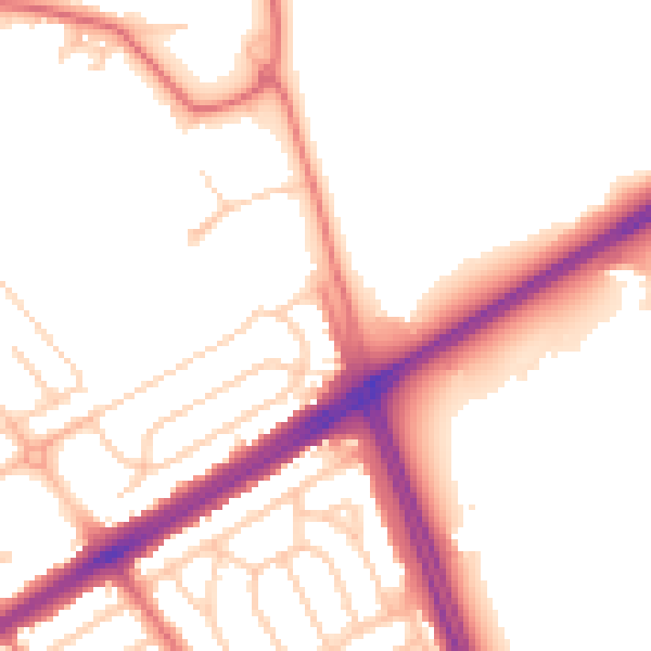
Daytime· 07:00 – 23:00
52.6dB

Night-time· 23:00 – 07:00
44.1dB