99 Gorsey Lane, Ford, Liverpool, L21 0DG
About 99 Gorsey Lane
99 Gorsey Lane is a three-bedroom mid-terrace house in Ford, Liverpool, Liverpool (L21 0DG). It has a recorded floor area of 77 m² (around 829 sq ft), construction records dating it to 1950-1966 and council tax band A. The latest certificate (May 2024) shows a C (score 70). The recommended improvements would push it to B (score 86).
Most recent transfer was December 2024 at £107,000 — fresh data. Across 1999–2024, sale prices on this property compounded at 3.8% per year. Today's modelled estimate of £143,000 is 33.6% above the 2024 sale price. On a £-per-square-foot basis, the last sale (£129/sq ft) was about 17.3% above the typical sold price in the postcode.
What this property has
Inside
- Bedrooms3
- Bathrooms1
Everything you need to know about 99 Gorsey Lane
The true value, the hidden risks and the full sale history, in one report.
30-day money-back guarantee

The data behind every report


Energy performance
EPC Rating
Planning history
99 Gorsey Lane has no planning applications on record.
Notable planning nearby
3applications of note in the surrounding area
Sales history & valuation
99 Gorsey Lane has more than doubled in price since the earliest registered sale in 1999.
£143,000
Modelled from EPC, postcode comparables and a sale-price growth of 3.8% per year over 26 years.
£107,000
Growth on file: 3.8% per year over 26 years.
Sales timeline
18 December 2024Most recent
£107,000
+159.4%over 25 years28 April 1999
£41,250
Median price across the last 5 sales in L21 0DG: £126,000 (2023–2020).
Nearby sales in L21 0DG
117 Gorsey Lane, Ford, Liverpool, L21 0DG
Sold May 2023
£145,000103 Gorsey Lane, Ford, Liverpool, L21 0DG
Sold Mar 2022
£126,000107 Gorsey Lane, Ford, Liverpool, L21 0DG
Sold Feb 2021
£130,000109 Gorsey Lane, Ford, Liverpool, L21 0DG
Sold Dec 2020
£90,00095 Gorsey Lane, Ford, Liverpool, L21 0DG
Sold Jan 2019
£66,000
Versus other Gorsey Lane homes
99 Gorsey Lane is notably below the street on years held.
Price per m²
£1,390
Street avg £1,345
Floor Area
77 m²
Street avg 73 m²
Habitable Rooms
5 rooms
Street avg 4 rooms
CO₂ Emissions
2.8 t/year
Street avg 2.8 t/year
Everything you need to know about 99 Gorsey Lane
The true value, the hidden risks and the full sale history, in one report.
30-day money-back guarantee
The data behind every report
Similar properties nearby
1 Kenmore Cottages, Gorsey Lane, Ford
L21 0EH
1 Bowland Drive
L21 0JA
1 Octavia Hill Road
L21 0DY
1 Ford Lane
L21 0HG
1 Kirkstone Road West
L21 0EG
1 Cemetery Cottages, Sterrix Lane
L21 0DD
1 Heathview
L21 0HA
1 Pankhurst Road
L21 0EE
The neighbourhood at a glance
Reported crime in the wider district is trending notably upward year-on-year.
Crime
4/mo
Rising year-on-year across the wider district.
Nearest stop
0.1 km
Green Lane — bus stop.
Closest school
0.4 km
Our Lady Queen of Peace Catholic Primary School. 36 schools nearby.
Go deeper on the local area
The full report breaks down crime, transport links, schools and air quality in depth.
Road noise across the postcode
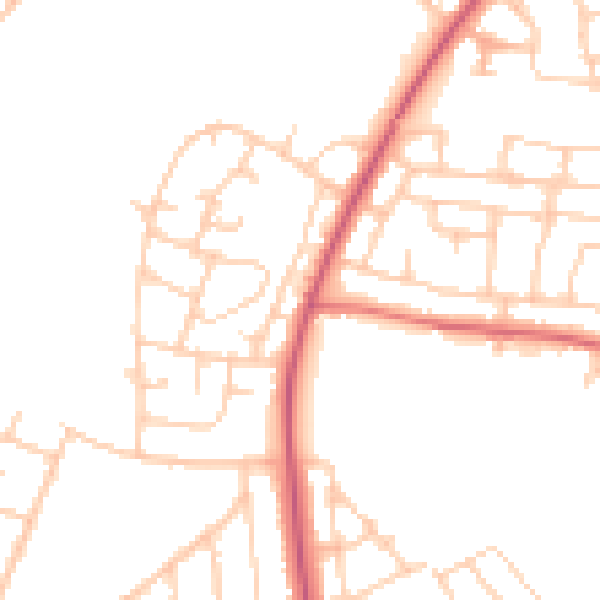
Daytime· 07:00 – 23:00
48.3dB

Night-time· 23:00 – 07:00
39.2dB