8 Evercroft Road, Liverpool, L14 7AF
About 8 Evercroft Road
8 Evercroft Road is a detached house in Liverpool (L14 7AF). It has a recorded floor area of 96 m² (around 1033 sq ft) and council tax band D. The latest certificate (June 2013) returns a B (score 82), comfortably above the UK average. The latest certificate is from June 2013, so improvements made since then won't be reflected.
One planning record on file: an extension approved in 2020. Past consents include an extension, meaningful when judging how the property has evolved. On the market in June 2013 and unlisted since — roughly 13 years. Today's modelled estimate of £301,000 is 46.8% above the 2013 sale price.
Everything you need to know about 8 Evercroft Road
The true value, the hidden risks and the full sale history, in one report.
Pick your report · every report is £14.99
One time fee only - money back guarantee

The data behind every report


Energy performance
8 Evercroft Road's EPC is over a decade old — improvements since won't be reflected.
EPC Expired
This certificate is over 10 years old and is no longer valid.Expired 11 Jun 2023
EPC Rating
Get a survey for this property
Level 2 HomeBuyer Report
We've checked 10 risk factors against the available data for this property and believe a Level 2 HomeBuyer Report could be a suitable option for you.
From £595 · Includes VAT
Planning history
Council records include a two-storey side extension at 8 Evercroft Road.
1 application on record at 8 Evercroft Road, Liverpool, L14 7AF
- Mar 2020ExtensionFullOutcome in report
Extension: Two storey · Side of property
DEMOLITION OF GARAGE AND ERECTION OF A TWO STOREY SIDE EXTENSION
- Documents
- 12 docs on file
- Reference
- 20/00035/FUL
Unlock 8 Evercroft Road, Liverpool, L14 7AF's full planning history
You're seeing the shape of it. The report has the substance.
- Every decision — granted, refused or withdrawn (1 on record)
- All 1 application on this property in full
- The 12 documents, officer reports & conditions
- What the pattern means for extending or converting here
One time fee only - money back guarantee
Sales history & valuation
£301,000
Modelled from EPC, postcode comparables.
£204,995
Recorded with HM Land Registry.
Sales timeline
20 June 2013Most recent
£204,995
Median price across the last 5 sales in L14 7AF: £247,500 (2025–2019).
Nearby sales in L14 7AF
Versus other Evercroft Road homes
8 Evercroft Road outperforms the street on years held by a wide margin.
Price per m²
£2,135
Street avg £2,540
Floor Area
96 m²
Street avg 100 m²
CO₂ Emissions
1.6 t/year
Street avg 1.7 t/year
Years Held
13 years
Street avg 9 years
Everything you need to know about 8 Evercroft Road
The true value, the hidden risks and the full sale history, in one report.
Pick your report · every report is £14.99
One time fee only - money back guarantee
The data behind every report
Similar properties nearby
The neighbourhood at a glance
Rail-style transport is unusually close for this postcode.
Crime
6/mo
Rising year-on-year across the wider district.
Nearest stop
0.1 km
Ashfield Way — bus stop.
Closest school
0.5 km
Malvern Primary School. 49 schools nearby.
Go deeper on the local area
A Local Area report breaks down crime, transport links, schools and air quality in depth.
Road noise across the postcode
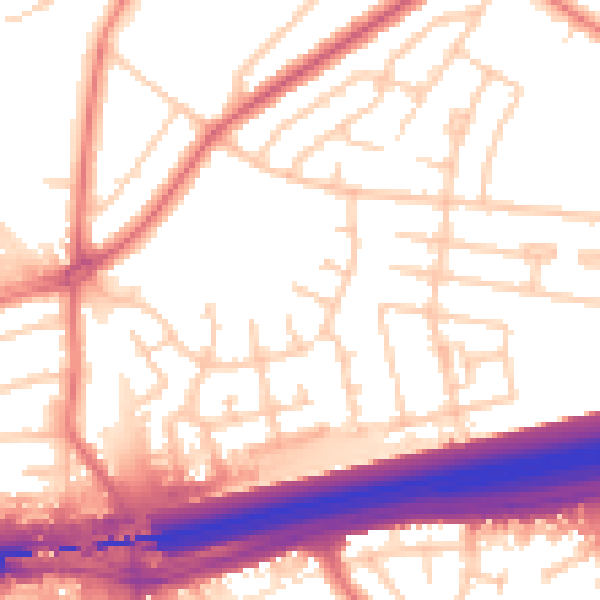
Daytime· 07:00 – 23:00
55.2dB

Night-time· 23:00 – 07:00
46.0dB