1 Ericsson Drive, Liverpool, L14 3AD
About 1 Ericsson Drive
1 Ericsson Drive is a semi-detached house in Liverpool (L14 3AD). It has a recorded floor area of 80 m² (around 861 sq ft) and council tax band C. The latest certificate (February 2015) returns a B (score 82), comfortably above the UK average. The recommended improvements would push it to A (score 95). The latest certificate is from February 2015, so improvements made since then won't be reflected.
Across 2016–2020, sale prices on this property compounded at -2.4% per year. Today's modelled estimate of £213,000 is 39.2% above the 2020 sale price. Sold December 2020 for £153,000.
Everything you need to know about 1 Ericsson Drive
The true value, the hidden risks and the full sale history, in one report.
Pick your report · every report is £14.99
One time fee only - money back guarantee

The data behind every report


Energy performance
1 Ericsson Drive's carbon output is low for the local stock.
EPC Expired
This certificate is over 10 years old and is no longer valid.Expired 11 Feb 2025
EPC Rating
Get a survey for this property
Level 2 HomeBuyer Report
We've checked 10 risk factors against the available data for this property and believe a Level 2 HomeBuyer Report could be a suitable option for you.
From £545 · Includes VAT
Planning history
1 Ericsson Drive has no planning applications on record.
A planning report still maps activity across the surrounding area and reads this property's extension & conversion potential.
Sales history & valuation
1 Ericsson Drive changed hands twice within eighteen months — unusual for the area.
£213,000
Modelled from EPC, postcode comparables and a sale-price growth of -2.4% per year over 5 years.
£153,000
Growth on file: -2.4% per year over 5 years.
Sales timeline
1 December 2020Most recent
£153,000
-8.1%over 10 months31 January 2020
£166,500
-2.6%over 3 years10 April 2016
£170,995
Median price across the last 5 sales in L14 3AD: £244,000 (2023–2021).
Nearby sales in L14 3AD
Versus other Ericsson Drive homes
Price per m² for 1 Ericsson Drive lags the street by a wide margin.
Price per m²
£1,913
Street avg £2,248
Floor Area
80 m²
Street avg 90 m²
CO₂ Emissions
1.3 t/year
Street avg 1.6 t/year
Years Held
6 years
Street avg 9 years
Everything you need to know about 1 Ericsson Drive
The true value, the hidden risks and the full sale history, in one report.
Pick your report · every report is £14.99
One time fee only - money back guarantee
The data behind every report
Similar properties nearby
1 Old Thomas Lane
L14 3NA
10 Norville Road
L14 3LY
10 Renville Road
L14 3LW
1 Renville Road
L14 3LN
10 Ericsson Drive
L14 3AD
1 Bowring Court, Roby Road, Bowring Park
L14 3NU
1 Jubilee Avenue
L14 3NB
10 Bowring Court, Roby Road, Bowring Park
L14 3NU
The neighbourhood at a glance
Rail-style transport is unusually close for this postcode.
Crime
6/mo
Rising year-on-year across the wider district.
Nearest stop
0.2 km
Queens Drive — bus stop.
Closest school
0.6 km
Dixons Broadgreen Academy. 52 schools nearby.
Go deeper on the local area
A Local Area report breaks down crime, transport links, schools and air quality in depth.
Road noise across the postcode
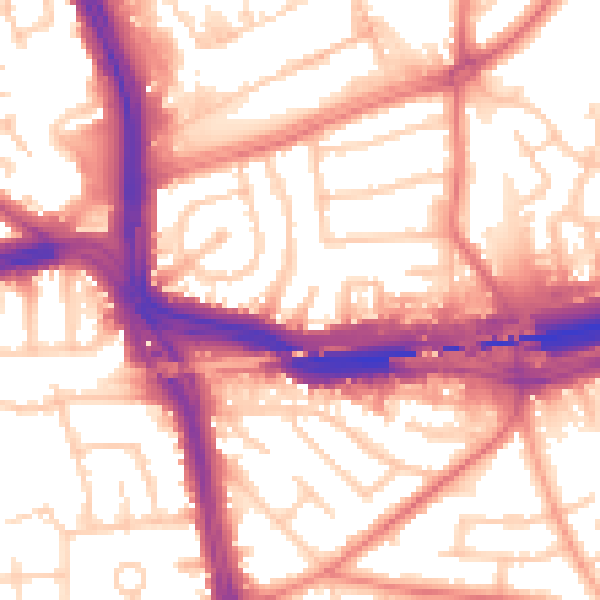
Daytime· 07:00 – 23:00
57.2dB

Night-time· 23:00 – 07:00
48.0dB