Are you a property professional?Get qualified leads from motivated homeowners.
Get started16 Courland Road, Addlestone, KT15 2UQ
1 planning record
About 16 Courland Road
A plain-English summary derived from public records, EPC certificates, sold prices and local data.
16 Courland Road is a three-bedroom semi-detached house in Addlestone (KT15 2UQ). It has a recorded floor area of 75 m² (around 812 sq ft), construction records dating it to 1950-1966 and council tax band D. The latest certificate (March 2011) shows a D (score 56), a step below the typical UK home. The recommended improvements would push it to C (score 70). The latest certificate is from March 2011, so improvements made since then won't be reflected.
Sale prices here have outpaced England HPI: 2.8% per year against 0% for the wider region. Today's modelled estimate of £401,000 sits 65.7% above the 2011 sale of £242,000. On a £-per-square-foot basis, the last sale (£298/sq ft) was about 26.7% above the typical sold price in the postcode. One planning record on file: an extension approved in 2015. Past consents include an extension, meaningful when judging how the property has evolved. On the market in September 2011 and unlisted since — roughly 15 years.
What this property has
Pulled from EPC certificates, claim submissions and our property model. Empty categories are hidden — we only show what's known.
Inside
- Bedrooms3
Energy performance
Every EPC certificate filed against this property — current rating, recorded improvements, and where there's headroom to reach a higher band.
16 Courland Road's EPC is over a decade old — improvements since won't be reflected.
EPC Expired
This certificate is over 10 years old and is no longer valid.Expired 12 Mar 2021
Planning history
Applications and permits filed against 16 Courland Road, Addlestone, KT15 2UQ, sourced from the PlanIt planning register.
- Jul 2015ExtensionAmendmentGrant Consent - subject to conditions
Extension: Single storey · Rear of property
Proposed lawful development certificate to establish whether planning permission is required for a single storey rear extension and raised decking area at rear following demolition of existing raised decking area at rear.
Sales history & valuation
Recorded transactions, our model's current estimate, and a quick read on what neighbouring properties have sold for.
16 Courland Road valuation sits well clear of the typical sold price in this postcode.
Current estimate
See how we calculated this£401,000
Modelled from EPC, postcode comparables and a sale-price growth of 2.8% per year over 6 years.
Last sold (2011)
£242,000
Growth on file: 2.8% per year over 6 years.
Sales timeline
Versus other Courland Road homes
Four headline reads against 13 similar houses on this street, drawn from the latest EPC and Land Registry data.
On years held, 16 Courland Road stands well clear of the street.
Price per m²
£3,208
Street avg £3,916
Floor Area
75 m²
Street avg 78 m²
Habitable Rooms
5 rooms
Street avg 5 rooms
Similar properties nearby
A handful of close matches in the same postcode area, ranked by likeness on bedrooms, type and floor area.
The neighbourhood at a glance
A condensed read of the local area. Each tile links through to the full breakdown on the Addlestone district page.
Rail-style transport is unusually close for this postcode.
Crime
3/mo
Steady year-on-year across the wider district.
Nearest stop
0.1 km
Chapel Park Road — bus stop.
Road noise across the postcode
Modelled day and night-time noise levels around KT15 2UQ from Defra's strategic mapping. The pin marks this postcode's centroid.
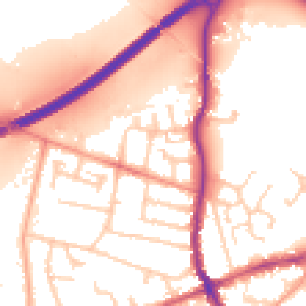
Daytime· 07:00 – 23:00
55.5dB

Everything within walking distance
Schools, transport stops and scenic spots near this property — 49 points of interest in total.
Beautiful places to visit nearby
Curated scenic spots within reach of this postcode, served by Beautifulplaces.ai. Photography and tagging come from their open dataset.
Common questions
The questions buyers, sellers and homeowners most often ask about 16 Courland Road, Addlestone, KT15 2UQ. Each answer is also embedded as structured data for search engines.