Are you a property professional?Get qualified leads from motivated homeowners.
Get started29 Haslemere Drive, Ipswich, IP4 2PP
About 29 Haslemere Drive
A plain-English summary derived from public records, EPC certificates, sold prices and local data.
29 Haslemere Drive is a three-bedroom mid-terrace house in Ipswich (IP4 2PP). It has a recorded floor area of 64 m² (around 689 sq ft), construction records dating it to 1976-1982 and council tax band B. Tenure is freehold. The latest certificate (December 2018) shows an E (score 49), well below the UK norm with real room to improve. The recommended improvements would lift it to B (score 91), a 3-band jump.
On energy efficiency it sits in the bottom 10% of properties in this postcode — significant headroom for improvement. Today's modelled estimate of £207,000 is 46.8% above the 2019 sale price. On a £-per-square-foot basis, the last sale (£205/sq ft) was about 30.8% above the typical sold price in the postcode. Sold March 2019 for £141,000.
What this property has
Pulled from EPC certificates, claim submissions and our property model. Empty categories are hidden — we only show what's known.
Inside
- Bedrooms3
- Bathrooms1
Outside
- Parkingallocated
Building
Energy performance
Every EPC certificate filed against this property — current rating, recorded improvements, and where there's headroom to reach a higher band.
29 Haslemere Drive sits at the bottom of the postcode for energy efficiency — meaningful headroom to improve.
EPC Rating
A
B
C
D
E
E49
F
G
Main Heating
Gas
Main Fuel
Gas
Hot Water
Very Poor
Windows
Average
CO2 Emissions
4.1 t/year
Occupancy
—
Sales history & valuation
Recorded transactions, our model's current estimate, and a quick read on what neighbouring properties have sold for.
29 Haslemere Drive valuation sits well clear of the typical sold price in this postcode.
Current estimate
See how we calculated this£207,000
Modelled from EPC, postcode comparables.
Last sold (2019)
£141,000
Recorded with HM Land Registry.
Sales timeline
Launch offer · 33% off
Buying 29 Haslemere Drive, Ipswich, IP4 2PP? Know what you're getting into
Everything a buyer needs to know about this property, compiled into one in-depth report so there are no surprises after you offer.
Spot red flags before you buy
An AI-written breakdown of everything that matters
Versus other Haslemere Drive homes
Four headline reads against 16 similar houses on this street, drawn from the latest EPC and Land Registry data.
29 Haslemere Drive is notably below the street on epc rating.
Price per m²
£2,203
Street avg £2,136
Floor Area
64 m²
Street avg 69 m²
Habitable Rooms
4 rooms
Street avg 4 rooms
Similar properties nearby
A handful of close matches in the same postcode area, ranked by likeness on bedrooms, type and floor area.
The neighbourhood at a glance
A condensed read of the local area. Each tile links through to the full breakdown on the Ipswich district page.
Reported crime in the wider district is trending notably upward year-on-year.
Crime
9/mo
Rising year-on-year across the wider district.
Nearest stop
0.2 km
Duke of York — bus stop.
Road noise across the postcode
Modelled day and night-time noise levels around IP4 2PP from Defra's strategic mapping. The pin marks this postcode's centroid.
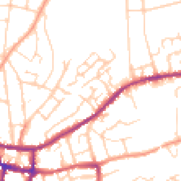
Daytime· 07:00 – 23:00
49.7dB

Everything within walking distance
Schools, transport stops and scenic spots near this property — 59 points of interest in total.
Common questions
The questions buyers, sellers and homeowners most often ask about 29 Haslemere Drive, Ipswich, IP4 2PP. Each answer is also embedded as structured data for search engines.
