8 Carisbrooke Avenue, Cottingham, HU16 4DX
About 8 Carisbrooke Avenue
8 Carisbrooke Avenue is a three-bedroom semi-detached house in Cottingham (HU16 4DX). It has a recorded floor area of 116 m² (around 1249 sq ft), construction records dating it to 1900-1929 and council tax band C. The latest certificate (August 2017) shows an E (score 42), well below the UK norm with real room to improve. The recommended improvements would push it to D (score 66). Period features are noted in the property record.
Untraded for 19 years, with the last transfer in December 2006. Today's modelled estimate of £274,000 sits 56.6% above the 2006 sale of £175,000.
What this property has
Inside
- Bedrooms3
- Dining roomYes
- FireplaceYes
Outside
- Private gardenYes
- GarageYes
Building
- Period featuresYes
Everything you need to know about 8 Carisbrooke Avenue
The true value, the hidden risks and the full sale history, in one report.
30-day money-back guarantee

The data behind every report


Energy performance
8 Carisbrooke Avenue's carbon output runs well above what efficient homes in the postcode produce.
EPC Rating
Planning history
8 Carisbrooke Avenue has no planning applications on record.
The full report still covers planning activity across the surrounding area.
Sales history & valuation
8 Carisbrooke Avenue valuation sits well clear of the typical sold price in this postcode.
£274,000
Modelled from EPC, postcode comparables.
£175,000
Recorded with HM Land Registry.
Sales timeline
8 December 2006Most recent
£175,000
Median price across the last 5 sales in HU16 4DX: £245,000 (2021–2018).
Nearby sales in HU16 4DX
2 Carisbrooke Avenue, Cottingham, HU16 4DX
Sold Sept 2021
£255,0004 Carisbrooke Avenue, Cottingham, HU16 4DX
Sold Jun 2019
£245,0003 Carisbrooke Avenue, Cottingham, HU16 4DX
Sold Feb 2018
£270,0007 Carisbrooke Avenue, Cottingham, HU16 4DX
Sold Nov 2017
£230,00011 Carisbrooke Avenue, Cottingham, HU16 4DX
Sold Mar 2017
£200,000
Versus other Carisbrooke Avenue homes
Price per m² for 8 Carisbrooke Avenue lags the street by a wide margin.
Price per m²
£1,509
Street avg £1,940
Floor Area
116 m²
Street avg 119 m²
Habitable Rooms
6 rooms
Street avg 6 rooms
CO₂ Emissions
7.1 t/year
Street avg 7.0 t/year
Everything you need to know about 8 Carisbrooke Avenue
The true value, the hidden risks and the full sale history, in one report.
30-day money-back guarantee
The data behind every report
Similar properties nearby
The neighbourhood at a glance
Rail-style transport is unusually close for this postcode.
Crime
4/mo
Steady year-on-year across the wider district.
Nearest stop
0.1 km
Cottingham Newgate Street — bus stop.
Closest school
0.3 km
Hallgate Primary School Cottingham. 18 schools nearby.
Go deeper on the local area
The full report breaks down crime, transport links, schools and air quality in depth.
Road noise across the postcode
Daytime· 07:00 – 23:00
49.3dB
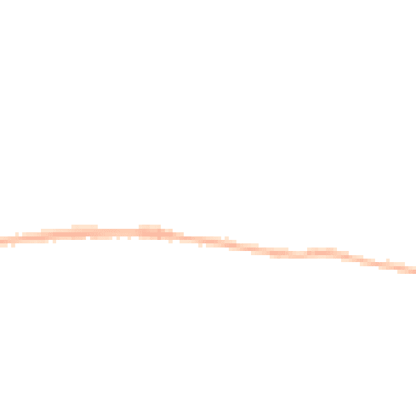
Night-time· 23:00 – 07:00
38.8dB