12 Brownswood Road, Beaconsfield, HP9 2NU
5 planning records
About 12 Brownswood Road
A plain-English summary derived from public records, EPC certificates, sold prices and local data.
12 Brownswood Road is a five-bedroom detached house in Beaconsfield (HP9 2NU). It has a recorded floor area of 340 m² (around 3660 sq ft), construction records dating it to 1967-1975 and council tax band H. The latest certificate (February 2026) shows a D (score 65), on the cusp of jumping into the C band. When first surveyed in June 2017 the rating was E, the property has climbed 1 band since. Between certificates, roof efficiency went from Very Poor to Average; while window efficiency dropped from Poor to Very Poor. The recommended improvements would push it to C (score 76). This certificate was lodged in the last six months, so the rating reflects current condition.
It hasn't traded since July 2003, a hold of 23 years that's notably long for the area. Sale prices here have outpaced England HPI: 15.6% per year against 0% for the wider region. Today's modelled estimate of £2,425,000 sits 102.1% above the 2003 sale of £1,200,000. On a £-per-square-foot basis, the last sale (£328/sq ft) was about 26.3% below the postcode norm. 5 planning records sit against the property, 0 approved, 0 refused, 1 pending. An application is currently awaiting a decision. At 340 m² it's 25.9% larger than the typical home in the postcode (270 m² median across 16 EPCs).
What this property has
Pulled from EPC certificates, claim submissions and our property model. Empty categories are hidden — we only show what's known.
Inside
- Bedrooms5
- Bathrooms4
Energy performance
Every EPC certificate filed against this property — current rating, recorded improvements, and where there's headroom to reach a higher band.
12 Brownswood Road's carbon output runs well above what efficient homes in the postcode produce.
Current Certificate(1 of 3)
Feb 2026
EPC Rating
A
B
C
D
D65
E
F
G
Main Heating
Gas
Main Fuel
Gas
Hot Water
Good
Windows
Very Poor
CO2 Emissions
9.9 t/year
Occupancy
Owner Occupied
Planning history
Applications and permits filed against 12 Brownswood Road, Beaconsfield, HP9 2NU, sourced from the PlanIt planning register.
There is a planning application currently awaiting a decision.
- Mar 2025MixedAmendmentPending
Non-material amendment to planning permission PL/23/3327/FA (Erection of a single detached self-build dwelling, with detached two bay garage and associated works. Part demolition of West elevation of existing property and alterations to existing ground and first floor layout. Formation of new vehicular access and driveway to serve new dwelling. Relocation of existing vehicular access for host property with existing access infilled.) to allow minor changes to the fenestration and addition of PV solar panels.
Sales history & valuation
Recorded transactions, our model's current estimate, and a quick read on what neighbouring properties have sold for.
Sale price has at least doubled since 1997.
Current estimate
See how we calculated this£2,425,000
Modelled from EPC, postcode comparables and a sale-price growth of 15.6% per year over 6 years.
Last sold (2003)
£1,200,000
Growth on file: 15.6% per year over 6 years.
Sales timeline
Launch offer · 33% off
The complete analysis of 12 Brownswood Road, Beaconsfield, HP9 2NU
Everything we know about this property, compiled into one in-depth, downloadable report.
Detailed analysis
A written breakdown of everything that matters
Versus other Brownswood Road homes
Four headline reads against 16 similar houses on this street, drawn from the latest EPC and Land Registry data.
Years Held for 12 Brownswood Road runs comfortably ahead of the street norm.
Price per m²
£3,529
Street avg £6,419
Floor Area
340 m²
Street avg 293 m²
Habitable Rooms
8 rooms
Similar properties nearby
A handful of close matches in the same postcode area, ranked by likeness on bedrooms, type and floor area.
The neighbourhood at a glance
A condensed read of the local area. Each tile links through to the full breakdown on the Beaconsfield district page.
Rail-style transport is unusually close for this postcode.
Crime
2/mo
Steady year-on-year across the wider district.
Nearest stop
0.2 km
Sandleswood End H&R — bus stop.
Road noise across the postcode
Modelled day and night-time noise levels around HP9 2NU from Defra's strategic mapping. The pin marks this postcode's centroid.
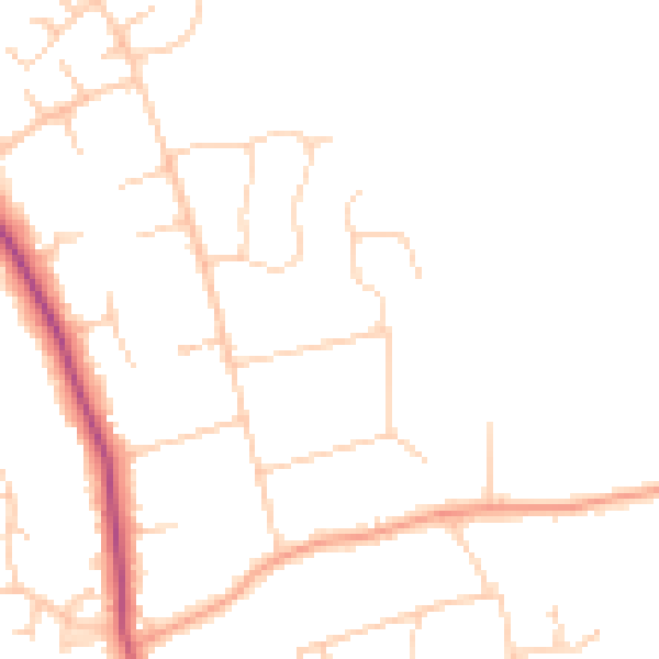
Daytime· 07:00 – 23:00
46.3dB

Everything within walking distance
Schools, transport stops and scenic spots near this property — 36 points of interest in total.
Common questions
The questions buyers, sellers and homeowners most often ask about 12 Brownswood Road, Beaconsfield, HP9 2NU. Each answer is also embedded as structured data for search engines.
