Are you a property professional?Get qualified leads from motivated homeowners.
Get started65 Oxenden Road, Tongham, Farnham, GU10 1AR
1 planning record
About 65 Oxenden Road
A plain-English summary derived from public records, EPC certificates, sold prices and local data.
65 Oxenden Road is a two-bedroom mid-terrace house in Tongham, Farnham, Farnham (GU10 1AR). It has a recorded floor area of 41 m² (around 441 sq ft), construction records dating it to 1930-1949 and council tax band C. The latest certificate (July 2009) shows a C (score 70). The latest certificate is from July 2009, so improvements made since then won't be reflected.
Untraded for 16 years, with the last transfer in December 2009. That sale fell during the post-crash dip, which often skews comparisons against later neighbouring sales. At 41 m² it sits well below the postcode median (70 m² across 24 EPCs), making it one of the more compact homes locally. On energy efficiency it sits in the top 10% of properties in this postcode. Today's modelled estimate of £303,000 sits 83.6% above the 2009 sale of £165,000. On a £-per-square-foot basis, the last sale (£374/sq ft) was about 16.3% above the typical sold price in the postcode. One planning record on file: an extension approved in 2010. Past consents include an extension, meaningful when judging how the property has evolved.
What this property has
Pulled from EPC certificates, claim submissions and our property model. Empty categories are hidden — we only show what's known.
Inside
- Bedrooms2
Outside
- Private gardenrear
Building
- Refurbished
Energy performance
Every EPC certificate filed against this property — current rating, recorded improvements, and where there's headroom to reach a higher band.
65 Oxenden Road ranks among the most efficient homes in the postcode for energy use.
EPC Expired
This certificate is over 10 years old and is no longer valid.Expired 31 Jul 2019
Planning history
Applications and permits filed against 65 Oxenden Road, Tongham, Farnham, GU10 1AR, sourced from the PlanIt planning register.
65 Oxenden Road has an approved single-storey rear extension on the planning record.
- Jul 2010ExtensionFullApprove
Extension: Single storey · Rear of property
Single storey rear extension.
Sales history & valuation
Recorded transactions, our model's current estimate, and a quick read on what neighbouring properties have sold for.
The latest sale fell during the post-2008 dip, often a low-water mark in price comparisons.
Current estimate
See how we calculated this£303,000
Modelled from EPC, postcode comparables.
Last sold (2009)
£165,000
Recorded with HM Land Registry.
Sales timeline
Versus other Oxenden Road homes
Four headline reads against 24 similar houses on this street, drawn from the latest EPC and Land Registry data.
65 Oxenden Road outperforms the street on epc rating by a wide margin.
Price per m²
£4,028
Street avg £4,591
Floor Area
41 m²
Street avg 74 m²
Habitable Rooms
3 rooms
Similar properties nearby
A handful of close matches in the same postcode area, ranked by likeness on bedrooms, type and floor area.
The neighbourhood at a glance
A condensed read of the local area. Each tile links through to the full breakdown on the Farnham district page.
Crime
3/mo
Steady year-on-year across the wider district.
Nearest stop
0.0 km
Phillips Close — bus stop.
Road noise across the postcode
Modelled day and night-time noise levels around GU10 1AR from Defra's strategic mapping. The pin marks this postcode's centroid.
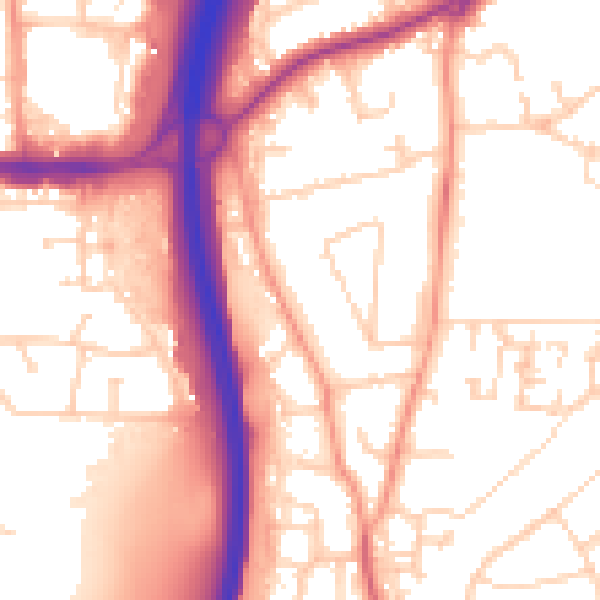
Daytime· 07:00 – 23:00
55.7dB

Everything within walking distance
Schools, transport stops and scenic spots near this property — 47 points of interest in total.
Beautiful places to visit nearby
Curated scenic spots within reach of this postcode, served by Beautifulplaces.ai. Photography and tagging come from their open dataset.
Common questions
The questions buyers, sellers and homeowners most often ask about 65 Oxenden Road, Tongham, Farnham, GU10 1AR. Each answer is also embedded as structured data for search engines.