7 Chantry Close, Lydney, GL15 5TH
About 7 Chantry Close
7 Chantry Close is a detached house in Lydney (GL15 5TH). It has a recorded floor area of 93 m² (around 1001 sq ft), construction records dating it to 1991-1995 and council tax band C. The latest certificate (April 2024) shows a C (score 72). The recommended improvements would push it to B (score 85).
Held since February 2003 — that's 23 years off the open market, well above the local norm. Across the public record there are 4 sales, relatively high churn for a single property. Across 1997–2003, sale prices on this property compounded at 12.2% per year. Today's modelled estimate of £339,000 sits 151.1% above the 2003 sale of £135,000.
Everything you need to know about 7 Chantry Close
The true value, the hidden risks and the full sale history, in one report.
30-day money-back guarantee

The data behind every report


Energy performance
EPC Rating
Planning history
7 Chantry Close has no planning applications on record.
Notable planning nearby
1applications of note in the surrounding area
We flagged 1 thing worth checking at 7 Chantry Close
Independent checks surfaced things a buyer would want to understand before offering. The report explains each one in full, with the underlying data and what to ask.
- Larger development activity nearby
30-day money-back guarantee
Sales history & valuation
7 Chantry Close's modelled value sits at over four times its earliest registered sale price (1997).
£339,000
Modelled from EPC, postcode comparables and a sale-price growth of 12.2% per year over 6 years.
£135,000
Growth on file: 12.2% per year over 6 years.
Sales timeline
21 February 2003Most recent
£135,000
+7.1%7 October 2002
£126,000
+44.8%over 1 year4 December 2000
£87,000
+27.1%over 3 years27 March 1997
£68,450
Median price across the last 5 sales in GL15 5TH: £337,000 (2024–2018).
Versus other Chantry Close homes
Habitable Rooms for 7 Chantry Close runs comfortably ahead of the street norm.
Price per m²
£1,452
Street avg £2,601
Floor Area
93 m²
Street avg 102 m²
Habitable Rooms
7 rooms
Street avg 6 rooms
CO₂ Emissions
2.9 t/year
Street avg 3.7 t/year
Everything you need to know about 7 Chantry Close
The true value, the hidden risks and the full sale history, in one report.
30-day money-back guarantee
The data behind every report
Similar properties nearby
The neighbourhood at a glance
Rail-style transport is unusually close for this postcode.
Crime
2/mo
Steady year-on-year across the wider district.
Nearest stop
0.1 km
Cemetery — bus stop.
Closest school
0.3 km
The Dean Academy. 5 schools nearby.
Go deeper on the local area
The full report breaks down crime, transport links, schools and air quality in depth.
Road noise across the postcode
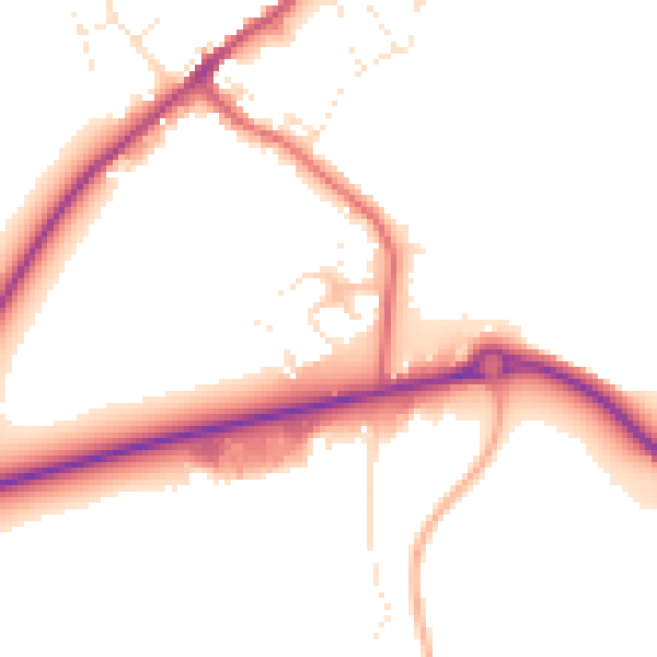
Daytime· 07:00 – 23:00
50.6dB

Night-time· 23:00 – 07:00
42.9dB