349 Lincoln Road, Enfield, EN3 4AD
About 349 Lincoln Road
349 Lincoln Road is a three-bedroom mid-terrace house in Enfield (EN3 4AD). It has a recorded floor area of 72 m² (around 772 sq ft), construction records dating it to 1900-1929 and council tax band C. The latest certificate (August 2011) shows a D (score 64), on the cusp of jumping into the C band. The latest certificate is from August 2011, so improvements made since then won't be reflected. Other recorded features include a balcony. Period features are noted in the property record. The home occupies a cul-de-sac position.
Today's modelled estimate of £398,000 sits 99% above the 2011 sale of £200,000. Last sold in November 2011, so it's been off the market for around 15 years.
What this property has
Inside
- Bedrooms3
- CloakroomYes
Outside
- Private gardenYes
- BalconyYes
- Cul-de-sacYes
Building
- Period featuresYes
Everything you need to know about 349 Lincoln Road
The true value, the hidden risks and the full sale history, in one report.
30-day money-back guarantee

The data behind every report


Energy performance
349 Lincoln Road's EPC is over a decade old — improvements since won't be reflected.
EPC Expired
This certificate is over 10 years old and is no longer valid.Expired 30 Aug 2021
EPC Rating
Planning history
349 Lincoln Road has no planning applications on record.
Notable planning nearby
39applications of note in the surrounding area
We flagged 1 thing worth checking at 349 Lincoln Road
Independent checks surfaced things a buyer would want to understand before offering. The report explains each one in full, with the underlying data and what to ask.
- Signs of HMO activity in the area
30-day money-back guarantee
Sales history & valuation
349 Lincoln Road valuation sits well clear of the typical sold price in this postcode.
£398,000
Modelled from EPC, postcode comparables.
£200,000
Recorded with HM Land Registry.
Sales timeline
4 November 2011Most recent
£200,000
Median price across the last 5 sales in EN3 4AD: £245,000 (2022–2004).
Versus other Lincoln Road homes
Habitable Rooms for 349 Lincoln Road lags the street by a wide margin.
Price per m²
£2,787
Street avg £3,291
Floor Area
72 m²
Street avg 82 m²
Habitable Rooms
3 rooms
Street avg 5 rooms
CO₂ Emissions
3.2 t/year
Street avg 4.6 t/year
Everything you need to know about 349 Lincoln Road
The true value, the hidden risks and the full sale history, in one report.
30-day money-back guarantee
The data behind every report
Similar properties nearby
The neighbourhood at a glance
Rail-style transport is unusually close for this postcode.
Crime
8/mo
Rising year-on-year across the wider district.
Nearest stop
0.0 km
Suffolk Road Enfield — bus stop.
Closest school
0.2 km
Heron Hall Academy. 46 schools nearby.
Go deeper on the local area
The full report breaks down crime, transport links, schools and air quality in depth.
Road noise across the postcode
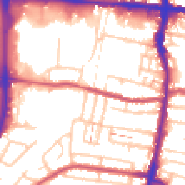
Daytime· 07:00 – 23:00
55.1dB

Night-time· 23:00 – 07:00
44.8dB