Colts Yard, Flat 8, 10 Aylmer Road, Waltham Forest, London, E11 3AD
About Colts Yard
Colts Yard is a one-bedroom property in Waltham Forest, London, London (E11 3AD). Other recorded features include a balcony.
Across 2005–2022, sale prices on this property compounded at 3.1% per year. Last sale on file: £328,500 in October 2022. That sale was during the post-pandemic price surge, when transactions cleared materially above pre-2020 trend. One historical planning record sits against the property in 2020.
Know exactly what you're buying at Colts Yard
Before you offer, see what the listing won't tell you, the true value, the red flags and the full history.
Already flagged here
Valuation
against the asking price
Risks
planning & flood
Sold prices
similar homes nearby
Trends
the local market
What this property has
Inside
- Bedrooms1
- Bathrooms1
- StudyYes
Outside
- Communal gardenYes
- ParkingAllocated
- BalconyYes
Energy performance
No EPC on record
This property doesn't have an Energy Performance Certificate yet. An EPC is required to sell or let — and unlocks our automated valuation.
Planning history
- Feb 2020RenovationFullIn report
Installation of seven roof lights to main roof and one window at second floor front elevation.
- Council
- LEYTONSTONE
- Reference
- 200340
We flagged 1 thing worth checking at Colts Yard
Independent checks surfaced things a buyer would want to understand before offering. The report explains each one in full, with the underlying data and what to ask.
- Signs of HMO activity in the area
30-day money-back guarantee
Sales history & valuation
The latest sale landed in the post-pandemic price surge — useful context when reading the figure.
£328,500
Growth on file: 3.1% per year over 17 years.
Sales timeline
27 October 2022Most recent
£328,500
+1.1%over 4 years29 July 2018
£325,000
+66.7%over 12 years26 September 2005
£195,000
Median price across the last 5 sales in E11 3AD: £450,000 (2025–2021).
Nearby sales in E11 3AD
Colts Yard, Flat 10, 10 Aylmer Road, Waltham Forest, London, E11 3AD
Sold Mar 2025
£450,000Colts Yard, Flat 6, 10 Aylmer Road, Waltham Forest, London, E11 3AD
Sold Feb 2024
£625,000Colts Yard, Flat 3, 10 Aylmer Road, Waltham Forest, London, E11 3AD
Sold Sept 2023
£440,00011 Aylmer Road, Waltham Forest, London, E11 3AD
Sold Jul 2023
£550,000Colts Yard, Flat 1, 10 Aylmer Road, Waltham Forest, London, E11 3AD
Sold Jun 2021
£441,050
Everything we know about Colts Yard, in one report
What it's really worth, what could be wrong, and the planning, sales and area data in full.
What we flagged
- Signs of HMO activity in the area

Similar properties nearby
11a, First Floor Flat, Wragby Road, Waltham Forest
E11 3LD
178a, Flat 5, High Road Leytonstone
E11 3HU
178a, Flat 4, High Road Leytonstone
E11 3HU
119b, Flat 2, Harrow Road, Waltham Forest
E11 3PX
178a, Flat 3, High Road Leytonstone
E11 3HU
178a, Flat 1, High Road Leytonstone
E11 3HU
178a, Flat 6, High Road Leytonstone
E11 3HU
178a, Flat 2, High Road Leytonstone
E11 3HU
The neighbourhood at a glance
Rail-style transport is unusually close for this postcode.
Crime
5/mo
Rising year-on-year across the wider district.
Nearest stop
0.1 km
Kirkdale Road — bus stop.
Closest school
0.4 km
George Tomlinson Primary School. 57 schools nearby.
Go deeper on the local area
The full report breaks down crime, transport links, schools and air quality in depth.
Road noise across the postcode
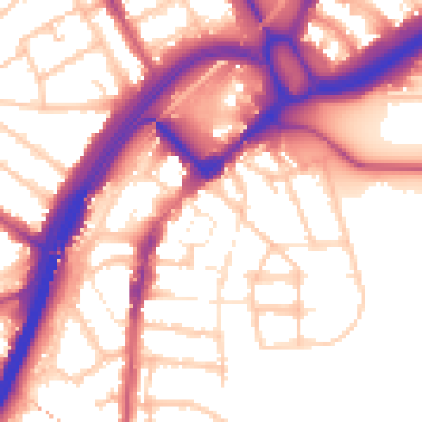
Daytime· 07:00 – 23:00
56.6dB

Night-time· 23:00 – 07:00
47.7dB