Belmont Court, Apartment 10, Belmont Road, Belmont, Durham, DH1 2QN
About Belmont Court
Belmont Court is a two-bedroom mid-terrace house in Belmont, Durham, Durham (DH1 2QN). It has a recorded floor area of 56 m² (around 603 sq ft), construction records dating it to 2003-2006 and council tax band B. At 56 m² this is the 14th smallest of 20 units on EPC record in Belmont Court, where floor areas span 40–79 m². The building's EPC ratings span D to B across 20 units on file. The latest certificate (November 2018) shows a C (score 77), near the top of the C band.
It hasn't traded since July 2009, a hold of 17 years that's notably long for the area. That sale fell during the post-crash dip, which often skews comparisons against later neighbouring sales. Across 2006–2009, sale prices on this property compounded at -10.7% per year.
What this property has
Inside
- Bedrooms2
Everything you need to know about Belmont Court
The true value, the hidden risks and the full sale history, in one report.
Pick your report · every report is £14.99
One time fee only - money back guarantee

The data behind every report


Energy performance
Belmont Court's carbon output is low for the local stock.
EPC Rating
Get a survey for this property
Level 2 HomeBuyer Report
We've checked 10 risk factors against the available data for this property and believe a Level 2 HomeBuyer Report could be a suitable option for you.
From £495 · Includes VAT
Planning history
Belmont Court has no planning applications on record.
But the area is active
35 notable applications nearby — larger schemes and conversions that could reshape the street. The report maps them all.
Sales history & valuation
The latest sale fell during the post-2008 dip, often a low-water mark in price comparisons.
£104,000
Modelled from EPC, postcode comparables and a sale-price growth of -10.7% per year over 4 years.
£107,000
Growth on file: -10.7% per year over 4 years.
Sales timeline
30 July 2009Most recent
£107,000
-33.1%over 3 years6 January 2006
£160,000
Median price across the last 5 sales in DH1 2QN: £120,000 (2025–2022).
Nearby sales in DH1 2QN
Belmont Court, Apartment 12, Belmont Road, Belmont, Durham, DH1 2QN
Sold Sept 2025
£95,000Belmont Court, Apartment 9, Belmont Road, Belmont, Durham, DH1 2QN
Sold Jul 2025
£120,000Belmont Court, Apartment 21, Belmont Road, Belmont, Durham, DH1 2QN
Sold Feb 2024
£130,000Belmont Court, Apartment 11, Belmont Road, Belmont, Durham, DH1 2QN
Sold Oct 2023
£100,000Belmont Court, Apartment 17, Belmont Road, Belmont, Durham, DH1 2QN
Sold Apr 2022
£120,000
Versus other Belmont Road homes
Price per m²
£1,911
Street avg £2,313
Floor Area
56 m²
Street avg 53 m²
Habitable Rooms
3 rooms
Street avg 3 rooms
CO₂ Emissions
1.5 t/year
Street avg 1.6 t/year
Everything you need to know about Belmont Court
The true value, the hidden risks and the full sale history, in one report.
Pick your report · every report is £14.99
One time fee only - money back guarantee
The data behind every report
Similar properties nearby
Belmont Court, Apartment 11, Belmont Road, Belmont
DH1 2QN
Belmont Court, Apartment 1, Belmont Road, Belmont
DH1 2QN
Belmont Court, Apartment 12, Belmont Road, Belmont
DH1 2QN
Belmont Court, Apartment 14, Belmont Road, Belmont
DH1 2QN
Belmont Court, Apartment 15, Belmont Road, Belmont
DH1 2QN
Belmont Court, Apartment 8, Belmont Road, Belmont
DH1 2QN
Belmont Court, Apartment 3, Belmont Road, Belmont
DH1 2QN
Belmont Court, Apartment 21, Belmont Road, Belmont
DH1 2QN
The neighbourhood at a glance
Crime
6/mo
Steady year-on-year across the wider district.
Nearest stop
0.0 km
Sportsmans Arms — bus stop.
Closest school
0.3 km
Belmont Community School. 12 schools nearby.
Go deeper on the local area
A Local Area report breaks down crime, transport links, schools and air quality in depth.
Road noise across the postcode
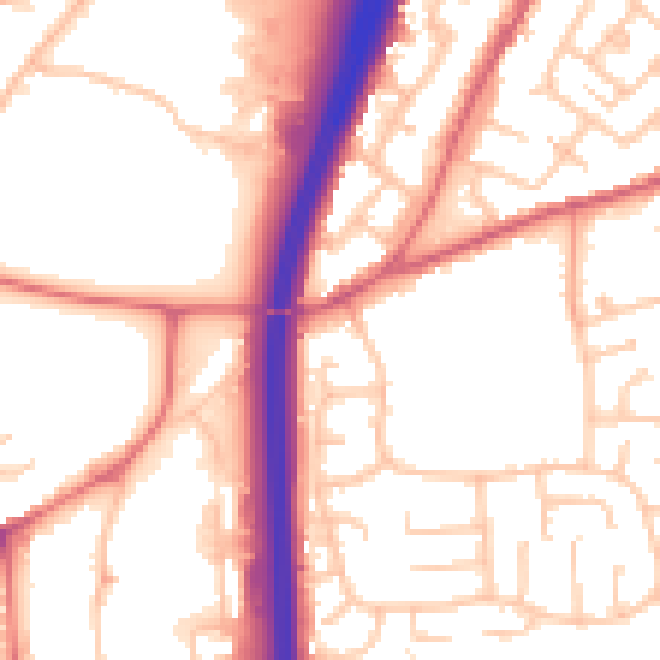
Daytime· 07:00 – 23:00
54.6dB

Night-time· 23:00 – 07:00
44.2dB