7 Hart Drive, Measham, Swadlincote, DE12 7PH
About 7 Hart Drive
7 Hart Drive is a two-bedroom mid-terrace house in Measham, Swadlincote, Swadlincote (DE12 7PH). It has a recorded floor area of 73 m² (around 786 sq ft), construction records dating it to 2007 onwards and council tax band B. The latest certificate (November 2011) shows a C (score 79), near the top of the C band. The latest certificate is from November 2011, so improvements made since then won't be reflected.
Most recent transfer: October 2020 at £155,000. Across the public record there are 4 sales, relatively high churn for a single property. Across 2012–2020, sale prices on this property compounded at 3.3% per year. Today's modelled estimate of £186,000 is 20% above the 2020 sale price.
Know exactly what you're buying at 7 Hart Drive
Before you offer, see what the listing won't tell you, the true value, the red flags and the full history.
Already flagged here
Valuation
against the asking price
Risks
planning & flood
Sold prices
similar homes nearby
Trends
the local market
What this property has
Inside
- Bedrooms2
- Bathrooms1
- Dining roomYes
- CloakroomYes
Outside
- Private gardenYes
- GarageSingle
Building
- Central heatingYes
Energy performance
7 Hart Drive's EPC is over a decade old — improvements since won't be reflected.
EPC Expired
This certificate is over 10 years old and is no longer valid.Expired 08 Nov 2021
EPC Rating
Planning history
7 Hart Drive has no planning applications on record.
Notable planning nearby
4applications of note in the surrounding area
We flagged 1 thing worth checking at 7 Hart Drive
Independent checks surfaced things a buyer would want to understand before offering. The report explains each one in full, with the underlying data and what to ask.
- Larger development activity nearby
30-day money-back guarantee
Sales history & valuation
7 Hart Drive saw 4 transfers in just over a decade — high turnover for the postcode.
£186,000
Modelled from EPC, postcode comparables and a sale-price growth of 3.3% per year over 8 years.
£155,000
Growth on file: 3.3% per year over 8 years.
Sales timeline
22 October 2020Most recent
£155,000
+5.4%over 2 years2 March 2018
£147,000
+8.9%over 2 years2 July 2015
£135,000
+14.4%over 3 years26 April 2012
£118,000
Median price across the last 5 sales in DE12 7PH: £315,000 (2025–2021).
Nearby sales in DE12 7PH
20 Hart Drive, Measham, Swadlincote, DE12 7PH
Sold Jul 2025
£315,00022 Hart Drive, Measham, Swadlincote, DE12 7PH
Sold Jul 2025
£280,00030 Hart Drive, Measham, Swadlincote, DE12 7PH
Sold Jul 2025
£330,00044 Hart Drive, Measham, Swadlincote, DE12 7PH
Sold Jul 2024
£320,00034 Hart Drive, Measham, Swadlincote, DE12 7PH
Sold Nov 2021
£285,000
Everything we know about 7 Hart Drive, in one report
What it's really worth, what could be wrong, and the planning, sales and area data in full.
What we flagged
- Larger development activity nearby

Versus other Hart Drive homes
Habitable Rooms for 7 Hart Drive lags the street by a wide margin.
Price per m²
£2,123
Street avg £2,350
Floor Area
73 m²
Street avg 80 m²
Habitable Rooms
3 rooms
Street avg 4 rooms
CO₂ Emissions
1.6 t/year
Street avg 1.9 t/year
Similar properties nearby
1 Adcocks Yard, High Street, Measham
DE12 7JA
1 Ash Drive, Measham
DE12 7LA
1 Browning Drive, Measham
DE12 7EE
1 Abney Crescent, Measham
DE12 7HH
1 Brickyard Cottages, Bosworth Road, Measham
DE12 7LH
1 Bleach Mill, Measham
DE12 7EP
1 Barklam Close, Donisthorpe
DE12 7QJ
1 Ashby Road, Donisthorpe
DE12 7QF
The neighbourhood at a glance
Crime
2/mo
Steady year-on-year across the wider district.
Nearest stop
0.4 km
Blackthorn Way — bus stop.
Closest school
0.6 km
Measham Church of England Primary School. 4 schools nearby.
Go deeper on the local area
The full report breaks down crime, transport links, schools and air quality in depth.
Road noise across the postcode
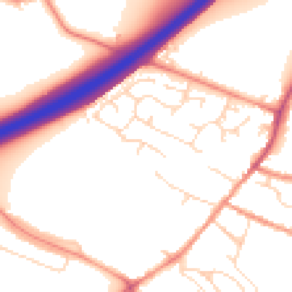
Daytime· 07:00 – 23:00
53.6dB

Night-time· 23:00 – 07:00
45.1dB