Are you a property professional?Get qualified leads from motivated homeowners.
Get started40 Goodenough Way, Coulsdon, CR5 1DY
About 40 Goodenough Way
A plain-English summary derived from public records, EPC certificates, sold prices and local data.
40 Goodenough Way is an end-of-terrace house in Coulsdon (CR5 1DY). It has a recorded floor area of 62 m² (around 667 sq ft), construction records dating it to 1967-1975 and council tax band C. At 62 m² this is the 11th smallest of 35 units on EPC record in the building, where floor areas span 47–112 m². The building's EPC ratings span E to A across 35 units on file. The latest certificate (October 2021) shows a C (score 78), near the top of the C band.
On a £-per-square-foot basis, the last sale (£360/sq ft) was about 66.5% above the typical sold price in the postcode. Most recent transfer: February 2022 at £240,000. That sale was during the post-pandemic price surge, when transactions cleared materially above pre-2020 trend.
Energy performance
Every EPC certificate filed against this property — current rating, recorded improvements, and where there's headroom to reach a higher band.
EPC Rating
A
B
C
C78
D
E
F
G
Main Heating
Gas
Main Fuel
Gas
Hot Water
Good
Windows
Average
CO2 Emissions
1.6 t/year
Occupancy
Owner Occupied
Sales history & valuation
Recorded transactions, our model's current estimate, and a quick read on what neighbouring properties have sold for.
The latest sale landed in the post-pandemic price surge — useful context when reading the figure.
Current estimate
See how we calculated this£244,000
Modelled from EPC, postcode comparables.
Last sold (2022)
£240,000
Recorded with HM Land Registry.
Sales timeline
Versus other Goodenough Way homes
Four headline reads against 26 similar flats on this street, drawn from the latest EPC and Land Registry data.
40 Goodenough Way outperforms the street on epc rating by a wide margin.
Price per m²
£3,871
Street avg £2,991
Floor Area
62 m²
Street avg 66 m²
Habitable Rooms
3 rooms
Similar properties nearby
A handful of close matches in the same postcode area, ranked by likeness on bedrooms, type and floor area.
The neighbourhood at a glance
A condensed read of the local area. Each tile links through to the full breakdown on the Coulsdon district page.
Daytime road noise here sits well below conversation level — a quiet pocket of the postcode.
Crime
4/mo
Steady year-on-year across the wider district.
Nearest stop
0.1 km
Road noise across the postcode
Modelled day and night-time noise levels around CR5 1DY from Defra's strategic mapping. The pin marks this postcode's centroid.
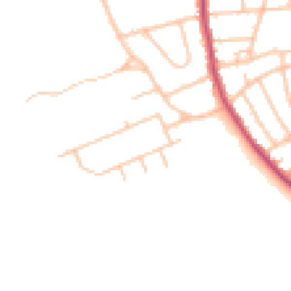
Daytime· 07:00 – 23:00
44.6dB

Everything within walking distance
Schools, transport stops and scenic spots near this property — 44 points of interest in total.
Beautiful places to visit nearby
Curated scenic spots within reach of this postcode, served by Beautifulplaces.ai. Photography and tagging come from their open dataset.
Common questions
The questions buyers, sellers and homeowners most often ask about 40 Goodenough Way, Coulsdon, CR5 1DY. Each answer is also embedded as structured data for search engines.