Are you a property professional?Get qualified leads from motivated homeowners.
Get started51 Edgar Road, South Croydon, CR2 0NJ
3 sales on record
About 51 Edgar Road
A plain-English summary derived from public records, EPC certificates, sold prices and local data.
51 Edgar Road is a three-bedroom semi-detached house in South Croydon (CR2 0NJ). It has a recorded floor area of 120 m² (around 1292 sq ft), construction records dating it to 1900-1929 and council tax band E. The latest certificate (August 2012) shows an E (score 46), well below the UK norm with real room to improve. The recommended improvements would lift it to C (score 79), a 2-band jump. The latest certificate is from August 2012, so improvements made since then won't be reflected. Period features are noted in the property record.
Sale prices here have outpaced England HPI: 6.3% per year against 0% for the wider region. On a £-per-square-foot basis, the last sale (£472/sq ft) was about 119.3% above the typical sold price in the postcode. One planning record on file: an extension approved in 2024. Past consents include an extension, meaningful when judging how the property has evolved. Most recent transfer: July 2022 at £610,000. That sale was during the post-pandemic price surge, when transactions cleared materially above pre-2020 trend.
What this property has
Pulled from EPC certificates, claim submissions and our property model. Empty categories are hidden — we only show what's known.
Inside
- Bedrooms3
- Bathrooms1
- Dining roomYes
- EnsuiteYes
Energy performance
Every EPC certificate filed against this property — current rating, recorded improvements, and where there's headroom to reach a higher band.
51 Edgar Road's carbon output runs well above what efficient homes in the postcode produce.
EPC Expired
This certificate is over 10 years old and is no longer valid.Expired 06 Aug 2022
Planning history
Applications and permits filed against 51 Edgar Road, South Croydon, CR2 0NJ, sourced from the PlanIt planning register.
- May 2024ExtensionOutlineGranted
Extension: Single storey · Rear of property
Erection of single storey rear extension, rear dormer extension and installation of front rooflights
Sales history & valuation
Recorded transactions, our model's current estimate, and a quick read on what neighbouring properties have sold for.
Price for 51 Edgar Road has grown more than fourfold since the 1998 starting point.
Current estimate
See how we calculated this£556,000
Modelled from EPC, postcode comparables and a sale-price growth of 6.3% per year over 24 years.
Last sold (2022)
£610,000
Growth on file: 6.3% per year over 24 years.
Sales timeline
Versus other Edgar Road homes
Four headline reads against 13 similar houses on this street, drawn from the latest EPC and Land Registry data.
Price per m² for 51 Edgar Road runs comfortably ahead of the street norm.
Price per m²
£5,083
Street avg £2,957
Floor Area
120 m²
Street avg 147 m²
Habitable Rooms
6 rooms
Similar properties nearby
A handful of close matches in the same postcode area, ranked by likeness on bedrooms, type and floor area.
The neighbourhood at a glance
A condensed read of the local area. Each tile links through to the full breakdown on the South Croydon district page.
Rail-style transport is unusually close for this postcode.
Crime
5/mo
Rising year-on-year across the wider district.
Nearest stop
0.2 km
Sanderstead Rail Station — railway station.
Road noise across the postcode
Modelled day and night-time noise levels around CR2 0NJ from Defra's strategic mapping. The pin marks this postcode's centroid.
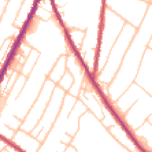
Daytime· 07:00 – 23:00
51.5dB

Everything within walking distance
Schools, transport stops and scenic spots near this property — 64 points of interest in total.
Beautiful places to visit nearby
Curated scenic spots within reach of this postcode, served by Beautifulplaces.ai. Photography and tagging come from their open dataset.
Common questions
The questions buyers, sellers and homeowners most often ask about 51 Edgar Road, South Croydon, CR2 0NJ. Each answer is also embedded as structured data for search engines.