47 Milton Road, Croydon, CR0 2BG
About 47 Milton Road
47 Milton Road is a mid-terrace house in Croydon (CR0 2BG). It has a recorded floor area of 60 m² (around 646 sq ft), construction records dating it to before 1900 and council tax band B. The latest certificate (March 2023) shows a C (score 77), near the top of the C band. The rating has held steady at C across 2 certificates since May 2013. Between certificates, lighting went from Average to Very Good.
At 60 m² it's 25% larger than the typical home in the postcode (48 m² median across 35 EPCs). Across 2006–2024, sale prices on this property compounded at 2.8% per year. On a £-per-square-foot basis, the last sale (£356/sq ft) was about 75.7% above the typical sold price in the postcode. Most recent transfer: November 2024 at £230,000.
Everything you need to know about 47 Milton Road
The true value, the hidden risks and the full sale history, in one report.
30-day money-back guarantee

The data behind every report


Energy performance
47 Milton Road's carbon output is low for the local stock.
EPC Rating
Property Improvements
Changes detected from historical EPC data
Heating controls upgraded for better temperature management
More low energy lighting installed
Planning history
47 Milton Road has no planning applications on record.
Notable planning nearby
64applications of note in the surrounding area
We flagged 2 things worth checking at 47 Milton Road
Independent checks surfaced things a buyer would want to understand before offering. The report explains each one in full, with the underlying data and what to ask.
- Signs of HMO activity in the area
- Larger development activity nearby
30-day money-back guarantee
Sales history & valuation
47 Milton Road valuation sits well clear of the typical sold price in this postcode.
£240,000
Modelled from EPC, postcode comparables and a sale-price growth of 2.8% per year over 19 years.
£230,000
Growth on file: 2.8% per year over 19 years.
Sales timeline
8 November 2024Most recent
£230,000
-6.1%over 7 years16 March 2017
£245,000
+78.2%over 10 years3 April 2006
£137,500
Median price across the last 5 sales in CR0 2BG: £178,000 (2024–2021).
Versus other Milton Road homes
On years held, 47 Milton Road runs well behind the street norm.
Price per m²
£3,833
Street avg £2,969
Floor Area
60 m²
Street avg 54 m²
Habitable Rooms
2 rooms
Street avg 3 rooms
CO₂ Emissions
1.5 t/year
Street avg 2.6 t/year
Everything you need to know about 47 Milton Road
The true value, the hidden risks and the full sale history, in one report.
30-day money-back guarantee
The data behind every report
Similar properties nearby
The neighbourhood at a glance
Rail-style transport is unusually close for this postcode.
Crime
6/mo
Steady year-on-year across the wider district.
Nearest stop
0.1 km
Lansdowne Road — bus stop.
Closest school
0.3 km
St. Mary's Catholic Junior School. 54 schools nearby.
Go deeper on the local area
The full report breaks down crime, transport links, schools and air quality in depth.
Road noise across the postcode
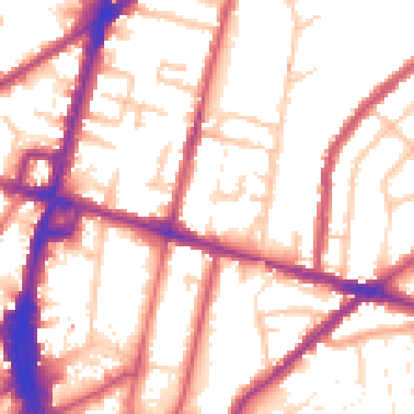
Daytime· 07:00 – 23:00
54.8dB

Night-time· 23:00 – 07:00
45.7dB