8 Portbury Way, Wirral, CH62 4SN
About 8 Portbury Way
8 Portbury Way is a three-bedroom end-of-terrace house in Wirral (CH62 4SN). It has a recorded floor area of 67 m² (around 721 sq ft), construction records dating it to 1996-2002 and council tax band B. Tenure is freehold. Other recorded features include a conservatory. Our model identifies extension potential, subject to local planning policy. The home occupies a cul-de-sac position. The latest certificate (July 2024) shows a C (score 74). The recommended improvements would push it to B (score 87).
Across 2006–2024, sale prices on this property compounded at 3% per year. Today's modelled estimate of £209,000 is 19.4% above the 2024 sale price. On a £-per-square-foot basis, the last sale (£243/sq ft) was about 208.4% above the typical sold price in the postcode. Sold September 2024 for £175,000.
Know exactly what you're buying at 8 Portbury Way
Before you offer, see what the listing won't tell you, the true value, the red flags and the full history.
Launch offer · save £5
Valuation
against the asking price
Risks
planning & flood
Sold prices
similar homes nearby
Trends
the local market
What this property has
Inside
- Bedrooms3
- Bathrooms1
- ConservatoryYes
Outside
- Private gardenYes
- Cul-de-sacYes
Building
- TenureFreehold
- RefurbishedYes
- Extension potentialPossible
Energy performance
EPC Rating
Planning history
8 Portbury Way has no planning applications on record.
The full report still covers planning activity across the surrounding area.
Sales history & valuation
Latest sale on 8 Portbury Way was the highest on Land Registry record across the postcode.
£209,000
Modelled from EPC, postcode comparables and a sale-price growth of 3.0% per year over 19 years.
£175,000
Growth on file: 3.0% per year over 19 years.
Sales timeline
19 September 2024Most recent
£175,000
+75.0%over 18 years27 January 2006
£100,000
Median price across the last 5 sales in CH62 4SN: £113,500 (2021–2006).
Everything we know about 8 Portbury Way, in one report
What it's really worth, what could be wrong, and the planning, sales and area data in full.
- Am I paying too much?
- Is something wrong with it?
- Is the agent's story true?
- Will it hold its value?

Versus other Portbury Way homes
Price per m² for 8 Portbury Way runs comfortably ahead of the street norm.
Price per m²
£2,612
Street avg £1,477
Floor Area
67 m²
Street avg 67 m²
Habitable Rooms
5 rooms
Street avg 3 rooms
CO₂ Emissions
2.0 t/year
Street avg 2.5 t/year
Similar properties nearby
1 Bolton Road East
CH62 4RU
1 Marshall Close, Bromborough Pool
CH62 4WA
1 William Burton Place, Bromborough Pool
CH62 4AF
1 Cross Street, Port Sunlight
CH62 4UN
1 Gorsey Vale, Bromborough Pool
CH62 4AE
1 Boniface Close, Bromborough Pool
CH62 4UG
1 The Moorings, Bromborough Pool
CH62 4ST
1 Bridge Street, Port Sunlight
CH62 4UW
The neighbourhood at a glance
Rail-style transport is unusually close for this postcode.
Crime
3/mo
Steady year-on-year across the wider district.
Nearest stop
0.1 km
Portbury Close — bus stop.
Closest school
0.3 km
Church Drive Primary School. 21 schools nearby.
Go deeper on the local area
The full report breaks down crime, transport links, schools and air quality in depth.
Road noise across the postcode
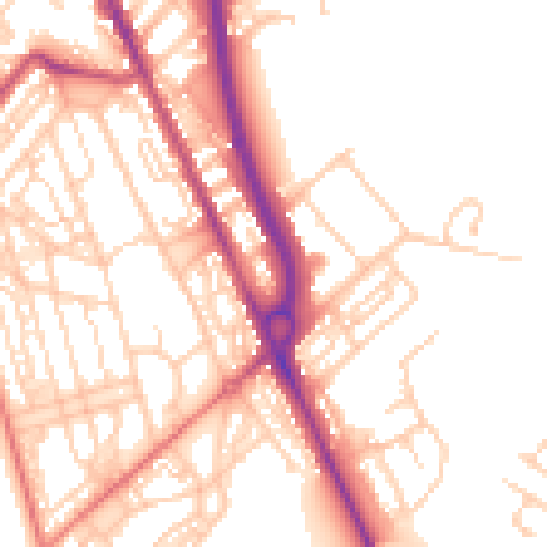
Daytime· 07:00 – 23:00
53.1dB

Night-time· 23:00 – 07:00
43.0dB