31 Mortimer Road, Filton, Bristol, BS34 7LE
About 31 Mortimer Road
31 Mortimer Road is a three-bedroom mid-terrace house in Filton, Bristol, Bristol (BS34 7LE). It has a recorded floor area of 68 m² (around 732 sq ft), construction records dating it to 1930-1949 and council tax band B. The latest certificate (December 2021) shows a D (score 67), on the cusp of jumping into the C band. The rating has held steady at D across 2 certificates since June 2016. Between certificates, roof efficiency went from Poor to Good and lighting went from Poor to Very Good; while window efficiency dropped from Good to Average. The recommended improvements would lift it to B (score 90), a 2-band jump.
Across 2016–2022, sale prices on this property compounded at 7.2% per year. On a £-per-square-foot basis, the last sale (£389/sq ft) was about 120.2% above the typical sold price in the postcode. At 68 m² it's 20% smaller than the typical home in the postcode (85 m² median across 13 EPCs). Sold May 2022 for £285,000. That sale was during the post-pandemic price surge, when transactions cleared materially above pre-2020 trend.
What this property has
Inside
- Bedrooms3
- Bathrooms1
- Dining roomYes
Outside
- Private gardenYes
- GarageYes
Building
- Heating systemGas
Everything you need to know about 31 Mortimer Road
The true value, the hidden risks and the full sale history, in one report.
Pick your report · every report is £14.99
One time fee only - money back guarantee

The data behind every report


Energy performance
Recommended upgrades on file would lift this property by multiple EPC bands.
EPC Rating
Property Improvements
Changes detected from historical EPC data
Heating controls upgraded for better temperature management
Loft insulation upgraded to recommended levels
More low energy lighting installed
Get a survey for this property
Level 3 Building Survey
Because the property has solid (non-cavity) walls, we believe a Level 3 building survey should be considered.
From £955 · Includes VAT
Planning history
31 Mortimer Road has no planning applications on record.
But the area is active
130 notable applications nearby — larger schemes and conversions that could reshape the street. The report maps them all.
Sales history & valuation
The latest sale landed in the post-pandemic price surge — useful context when reading the figure.
£312,000
Modelled from EPC, postcode comparables and a sale-price growth of 7.2% per year over 6 years.
£285,000
Growth on file: 7.2% per year over 6 years.
Sales timeline
16 May 2022Most recent
£285,000
+47.7%over 5 years13 October 2016
£193,000
Median price across the last 5 sales in BS34 7LE: £311,500 (2025–2019).
Nearby sales in BS34 7LE
9 Mortimer Road, Filton, Bristol, BS34 7LE
Sold Jul 2025
£311,5003 Mortimer Road, Filton, Bristol, BS34 7LE
Sold Jul 2024
£410,00043 Mortimer Road, Filton, Bristol, BS34 7LE
Sold Aug 2023
£315,00019 Mortimer Road, Filton, Bristol, BS34 7LE
Sold Dec 2020
£292,00017 Mortimer Road, Filton, Bristol, BS34 7LE
Sold Jun 2019
£230,000
Versus other Mortimer Road homes
Price per m² for 31 Mortimer Road runs comfortably ahead of the street norm.
Price per m²
£4,191
Street avg £2,679
Floor Area
68 m²
Street avg 87 m²
Habitable Rooms
4 rooms
Street avg 5 rooms
CO₂ Emissions
2.8 t/year
Street avg 3.6 t/year
Everything you need to know about 31 Mortimer Road
The true value, the hidden risks and the full sale history, in one report.
Pick your report · every report is £14.99
One time fee only - money back guarantee
The data behind every report
Similar properties nearby
1 Canberra Grove, Filton
BS34 7DH
1 Blenheim Drive, Filton
BS34 7AX
1 Concorde House, Bevan Court, Filton
BS34 7QN
1 Glebelands Road, Filton
BS34 7AD
1 Charlton Avenue
BS34 7QX
1 Elm Park, Filton
BS34 7PR
1 Clyde Grove, Filton
BS34 7RL
1 Dunkeld Avenue, Filton
BS34 7RH
The neighbourhood at a glance
Rail-style transport is unusually close for this postcode.
Crime
6/mo
Steady year-on-year across the wider district.
Nearest stop
0.1 km
Wallscourt Road — bus stop.
Closest school
0.4 km
Shield Road Primary School. 20 schools nearby.
Go deeper on the local area
A Local Area report breaks down crime, transport links, schools and air quality in depth.
Road noise across the postcode
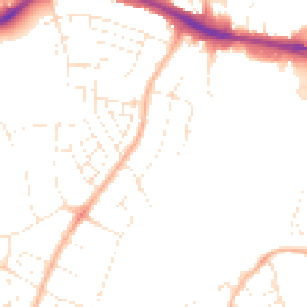
Daytime· 07:00 – 23:00
48.0dB

Night-time· 23:00 – 07:00
38.4dB