Flat 3, 25 Cecil Road, Bournemouth, BH5 1DX
About Flat 3
Flat 3 is a one-bedroom semi-detached house in Bournemouth (BH5 1DX). It has a recorded floor area of 31 m² (around 334 sq ft), construction records dating it to 1900-1929 and council tax band A. At 31 m² this is the 2nd smallest of 6 units on EPC record in the building, where floor areas span 24–82 m². The building's EPC ratings span D to C, with this unit at the bottom. On EPC score it ranks last in the building (57 versus a best of 78). The latest certificate (October 2013) shows a D (score 57), a step below the typical UK home. The recommended improvements would push it to C (score 74). Main heating runs on electricity. The latest certificate is from October 2013, so improvements made since then won't be reflected.
At 31 m² it sits well below the postcode median (45 m² across 31 EPCs), making it one of the more compact homes locally. On a £-per-square-foot basis, the last sale (£320/sq ft) was about 30.7% above the typical sold price in the postcode. On the market in August 2014 and unlisted since — roughly 12 years.
What this property has
Inside
- Bedrooms1
Everything you need to know about Flat 3
The true value, the hidden risks and the full sale history, in one report.
Pick your report · every report is £14.99
One time fee only - money back guarantee

The data behind every report


Energy performance
Flat 3's EPC is over a decade old — improvements since won't be reflected.
EPC Expired
This certificate is over 10 years old and is no longer valid.Expired 13 Oct 2023
EPC Rating
Get a survey for this property
Level 3 Building Survey
Because the property was built before 1919 and has no mains gas supply, we believe a Level 3 building survey should be considered.
From £820 · Includes VAT
Planning history
Flat 3 has no planning applications on record.
But the area is active
5 notable applications nearby — larger schemes and conversions that could reshape the street. The report maps them all.
Sales history & valuation
£116,000
Modelled from EPC, postcode comparables.
£106,750
Recorded with HM Land Registry.
Sales timeline
7 August 2014Most recent
£106,750
Median price across the last 5 sales in BH5 1DX: £139,000 (2025–2023).
Nearby sales in BH5 1DX
Flat 3, 21 Cecil Road, Bournemouth, BH5 1DX
Sold Sept 2025
£135,000Flat 8, 29 Cecil Road, Bournemouth, BH5 1DX
Sold Oct 2024
£139,000Flat 4, 27 Cecil Road, Bournemouth, BH5 1DX
Sold Oct 2024
£135,000Flat 7, 29 Cecil Road, Bournemouth, BH5 1DX
Sold Aug 2023
£175,000Flat 6, 29 Cecil Road, Bournemouth, BH5 1DX
Sold Jan 2023
£192,000
Versus other Cecil Road homes
Flat 3 is notably below the street on epc rating.
Price per m²
£3,444
Street avg £2,834
Floor Area
31 m²
Street avg 49 m²
Habitable Rooms
2 rooms
Street avg 3 rooms
CO₂ Emissions
2.1 t/year
Street avg 2.0 t/year
Everything you need to know about Flat 3
The true value, the hidden risks and the full sale history, in one report.
Pick your report · every report is £14.99
One time fee only - money back guarantee
The data behind every report
Similar properties nearby
12 14, Flat C, Roumelia Lane
BH5 1EU
1a, Flat 11, Crabton Close Road
BH5 1BW
1a, Flat 12, Crabton Close Road
BH5 1BW
1a, Flat 8, Crabton Close Road
BH5 1BW
1a, Flat 4, Crabton Close Road
BH5 1BW
1a, Flat 3, Crabton Close Road
BH5 1BW
1a, Flat 7, Crabton Close Road
BH5 1BW
1a, Flat 10, Crabton Close Road
BH5 1BW
The neighbourhood at a glance
Reported crime in the wider district is trending notably upward year-on-year.
Crime
6/mo
Rising year-on-year across the wider district.
Nearest stop
0.1 km
Boscombe Crescent — bus stop.
Closest school
0.6 km
Bethany Church of England Junior School. 18 schools nearby.
Go deeper on the local area
A Local Area report breaks down crime, transport links, schools and air quality in depth.
Road noise across the postcode
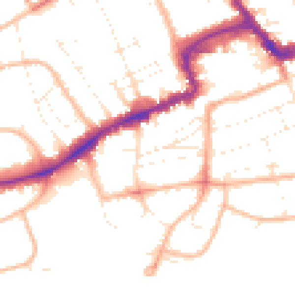
Daytime· 07:00 – 23:00
50.5dB

Night-time· 23:00 – 07:00
41.0dB