2 Rosedale Walk, Bridlington, YO16 4BW
About 2 Rosedale Walk
2 Rosedale Walk is an end-of-terrace house in Bridlington (YO16 4BW). It has a recorded floor area of 80 m² (around 861 sq ft), construction records dating it to 1967-1975 and council tax band A. The latest certificate (July 2020) shows a D (score 65), on the cusp of jumping into the C band. The recommended improvements would lift it to B (score 83), a 2-band jump.
Across 1999–2021, sale prices on this property compounded at 6.1% per year. Today's modelled estimate of £127,000 is 15.5% above the 2021 sale price. Last sale on file: £110,000 in February 2021. That sale was during the post-pandemic price surge, when transactions cleared materially above pre-2020 trend.
Know exactly what you're buying at 2 Rosedale Walk
Before you offer, see what the listing won't tell you, the true value, the red flags and the full history.
Valuation
against the asking price
Risks
planning & flood
Sold prices
similar homes nearby
Trends
the local market
Energy performance
Recommended upgrades on file would lift this property by multiple EPC bands.
EPC Rating
Planning history
2 Rosedale Walk has no planning applications on record.
The full report still covers planning activity across the surrounding area.
Sales history & valuation
Sale price has grown by over 3x since 1999.
£127,000
Modelled from EPC, postcode comparables and a sale-price growth of 6.1% per year over 22 years.
£110,000
Growth on file: 6.1% per year over 22 years.
Sales timeline
5 February 2021Most recent
£110,000
+266.7%over 21 years30 March 1999
£30,000
Median price across the last 3 sales in YO16 4BW: £95,000 (2017–2006).
Everything we know about 2 Rosedale Walk, in one report
What it's really worth, what could be wrong, and the planning, sales and area data in full.
- Am I paying too much?
- Is something wrong with it?
- Is the agent's story true?
- Will it hold its value?

Versus other Rosedale Walk homes
CO₂ Emissions for 2 Rosedale Walk lags the street by a wide margin.
EPC Rating
65 (D)
Street avg 69 (C)
Floor Area
80 m²
Street avg 77 m²
CO₂ Emissions
3.8 t/year
Street avg 3.0 t/year
Habitable Rooms
5 rooms
Street avg 4 rooms
Similar properties nearby
The neighbourhood at a glance
Reported crime in the wider district is trending notably upward year-on-year.
Crime
4/mo
Rising year-on-year across the wider district.
Nearest stop
0.2 km
Bridlington Bessingby Hill — bus stop.
Closest school
0.3 km
New Pasture Lane Primary School. 11 schools nearby.
Go deeper on the local area
The full report breaks down crime, transport links, schools and air quality in depth.
Road noise across the postcode
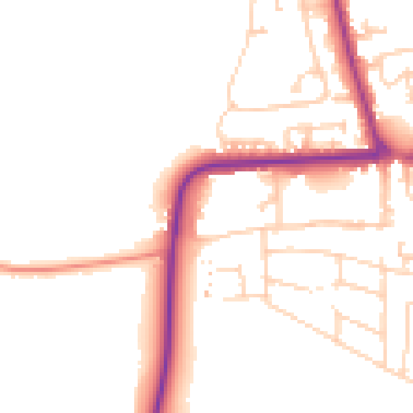
Daytime· 07:00 – 23:00
49.6dB

Night-time· 23:00 – 07:00
41.9dB