7 Popeley Grange, Liversedge, WF15 6AX
About 7 Popeley Grange
7 Popeley Grange is a semi-detached house in Liversedge (WF15 6AX). It has a recorded floor area of 88 m² (around 947 sq ft) and council tax band C. The latest certificate (September 2014) returns a B (score 83), comfortably above the UK average. The recommended improvements would push it to A (score 94). The latest certificate is from September 2014, so improvements made since then won't be reflected.
Last sold in September 2014, so it's been off the market for around 12 years. At 88 m² it's 20.7% smaller than the typical home in the postcode (111 m² median across 14 EPCs). Today's modelled estimate of £232,000 is 45% above the 2014 sale price.
Know exactly what you're buying at 7 Popeley Grange
Before you offer, see what the listing won't tell you, the true value, the red flags and the full history.
Launch offer · save £5
Valuation
against the asking price
Risks
planning & flood
Sold prices
similar homes nearby
Trends
the local market
Energy performance
7 Popeley Grange's carbon output is low for the local stock.
EPC Expired
This certificate is over 10 years old and is no longer valid.Expired 25 Sept 2024
EPC Rating
Planning history
7 Popeley Grange has no planning applications on record.
The full report still covers planning activity across the surrounding area.
Sales history & valuation
Latest sale on 7 Popeley Grange was the lowest on Land Registry record across the postcode.
£232,000
Modelled from EPC, postcode comparables.
£160,000
Recorded with HM Land Registry.
Sales timeline
25 September 2014Most recent
£160,000
Median price across the last 5 sales in WF15 6AX: £350,000 (2025–2024).
Nearby sales in WF15 6AX
Everything we know about 7 Popeley Grange, in one report
What it's really worth, what could be wrong, and the planning, sales and area data in full.
- Am I paying too much?
- Is something wrong with it?
- Is the agent's story true?
- Will it hold its value?

Versus other Popeley Grange homes
Years Held for 7 Popeley Grange runs comfortably ahead of the street norm.
Price per m²
£1,818
Street avg £2,452
Floor Area
88 m²
Street avg 115 m²
CO₂ Emissions
1.5 t/year
Street avg 2.1 t/year
Years Held
12 years
Street avg 6 years
Similar properties nearby
1 Churchfield Terrace
WF15 6LH
1 Eddercliffe Crescent
WF15 6LR
1 Dacre Close
WF15 6QX
1 Edward Street, Knowler Hill
WF15 6PJ
1 Firthcliffe Mount
WF15 6AN
1 Firthcliffe View
WF15 6AQ
1 Firthcliffe Lane
WF15 6HG
1 Firthcliffe Road
WF15 6HB
The neighbourhood at a glance
Crime
3/mo
Steady year-on-year across the wider district.
Nearest stop
0.2 km
Leeds Rd Thornleigh Drive — bus stop.
Closest school
0.4 km
Millbridge, A Share Primary Academy. 30 schools nearby.
Go deeper on the local area
The full report breaks down crime, transport links, schools and air quality in depth.
Road noise across the postcode
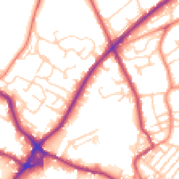
Daytime· 07:00 – 23:00
54.4dB

Night-time· 23:00 – 07:00
44.5dB