Stephen House, Flat 11, Chapel Street, Knottingley, WF11 9AW
1 planning record
About Stephen House
A plain-English summary derived from public records, EPC certificates, sold prices and local data.
Stephen House is a mid-terrace house in Knottingley (WF11 9AW). It has a recorded floor area of 48 m² (around 517 sq ft) and construction records dating it to 1900-1929. The latest certificate (April 2021) shows a C (score 69), just inside the C band. When first surveyed in April 2015 the rating was E, the property has climbed 2 bands since. Between certificates, window efficiency went from Poor to Good; while roof efficiency dropped from Good to Very Poor.
At 48 m² the property is well over the postcode median (35 m² across 11 EPCs), placing it in the larger end of the local stock. On energy efficiency it sits in the top 10% of properties in this postcode. One planning record on file: subdivision approved in 2020. Past consents include subdivision, meaningful when judging how the property has evolved.
Before you offer
Know exactly what you're buying at Stephen House
Before you offer, see what the listing won't tell you, the true value, the red flags and the full history.
Already flagged here
Larger development activity nearby
£9.99£14.99
Launch offer · save £5
Energy performance
Every EPC certificate filed against this property — current rating, recorded improvements, and where there's headroom to reach a higher band.
Stephen House ranks among the most efficient homes in the postcode for energy use.
Current Certificate(1 of 3)
Apr 2021
EPC Rating
A
B
C
C69
D
E
F
G
Main Heating
Gas
Main Fuel
Gas
Hot Water
Good
Windows
Good
CO2 Emissions
2.2 t/year
Occupancy
Rented
Planning history
Applications and permits filed against Stephen House, Flat 11, Chapel Street, Knottingley, WF11 9AW, sourced from the PlanIt planning register.
Council records show a subdivision application — the property's legal arrangement has been altered.
- Dec 2020SubdivisionFullIn report
Before you offer
We flagged 1 thing worth checking at Stephen House
Independent checks surfaced things a buyer would want to understand before offering. The report explains each one in full, with the underlying data and what to ask.
- Larger development activity nearby
£9.99£14.99
30-day money-back guarantee
Sales history & valuation
Recorded transactions, our model's current estimate, and a quick read on what neighbouring properties have sold for.
Stephen House has no Land Registry sales on file, suggesting it has stayed in the same hands since registration began.
Current estimate
See how we calculated this£156,000
Modelled from EPC, postcode comparables.
No sales recorded with HM Land Registry
That can mean the property has never traded since the registry began publishing in 1995, was a new build that hasn't been registered yet, or is held in the same hands long-term.
Before you offerLaunch offer · save £5
Everything we know about Stephen House, in one report
What it's really worth, what could be wrong, and the planning, sales and area data in full.
What we flagged
- Larger development activity nearby
£9.99£14.99
Versus other Chapel Street homes
Four headline reads against 11 similar flats on this street, drawn from the latest EPC and Land Registry data.
On epc rating, Stephen House stands well clear of the street.
EPC Rating
69 (C)
Street avg 58 (D)
Floor Area
48 m²
Street avg 40 m²
CO₂ Emissions
2.2 t/year
Street avg 2.6 t/year
Similar properties nearby
A handful of close matches in the same postcode area, ranked by likeness on bedrooms, type and floor area.
The neighbourhood at a glance
A condensed read of the local area. Each tile links through to the full breakdown on the Knottingley district page.
Daytime road noise here sits well below conversation level — a quiet pocket of the postcode.
Crime
5/mo
Steady year-on-year across the wider district.
Nearest stop
0.0 km
Road noise across the postcode
Modelled day and night-time noise levels around WF11 9AW from Defra's strategic mapping. The pin marks this postcode's centroid.
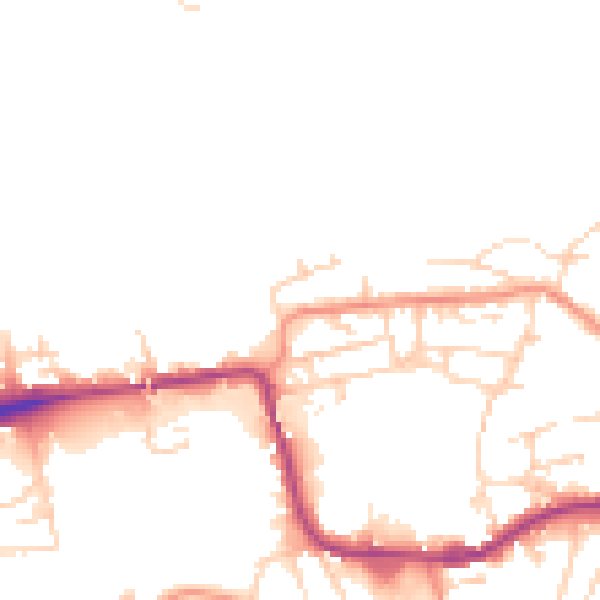
Daytime· 07:00 – 23:00
47.7dB

Everything within walking distance
Schools, transport stops and scenic spots near this property — 37 points of interest in total.
Common questions
The questions buyers, sellers and homeowners most often ask about Stephen House, Flat 11, Chapel Street, Knottingley, WF11 9AW. Each answer is also embedded as structured data for search engines.
