Are you a property professional?Get qualified leads from motivated homeowners.
Get started32 Balfour Road, Ealing, London, W13 9TN
Extendable
About 32 Balfour Road
A plain-English summary derived from public records, EPC certificates, sold prices and local data.
32 Balfour Road is a two-bedroom mid-terrace house in Ealing, London, London (W13 9TN). It has a recorded floor area of 84 m² (around 904 sq ft), construction records dating it to 1900-1929 and council tax band E. The latest certificate (June 2022) shows a D (score 66), on the cusp of jumping into the C band. The recommended improvements would lift it to B (score 86), a 2-band jump. Our model identifies extension potential, subject to local planning policy.
One planning record on file: a loft conversion approved in 2024. Past consents include a loft conversion, meaningful when judging how the property has evolved. Today's modelled estimate of £789,000 is 20% above the 2023 sale price. On a £-per-square-foot basis, the last sale (£727/sq ft) was about 83.2% above the typical sold price in the postcode. Sold September 2023 for £657,500.
What this property has
Pulled from EPC certificates, claim submissions and our property model. Empty categories are hidden — we only show what's known.
Inside
- Bedrooms2
- Bathrooms1
Outside
- Private gardenYes
Building
Energy performance
Every EPC certificate filed against this property — current rating, recorded improvements, and where there's headroom to reach a higher band.
Recommended upgrades on file would lift this property by multiple EPC bands.
EPC Rating
A
B
C
D
D66
E
F
G
Main Heating
Gas
Main Fuel
Gas
Hot Water
Good
Windows
Average
CO2 Emissions
3.2 t/year
Occupancy
Owner Occupied
Planning history
Applications and permits filed against 32 Balfour Road, Ealing, London, W13 9TN, sourced from the PlanIt planning register.
- Oct 2024Loft ConversionOutlineGranted
Rear roof extension, and installation of two roof lights to front roof slope (Lawful Development Certificate for a Proposed Development)
Sales history & valuation
Recorded transactions, our model's current estimate, and a quick read on what neighbouring properties have sold for.
32 Balfour Road valuation sits well clear of the typical sold price in this postcode.
Current estimate
See how we calculated this£789,000
Modelled from EPC, postcode comparables.
Last sold (2023)
£657,500
Recorded with HM Land Registry.
Sales timeline
Launch offer · 33% off
The complete analysis of 32 Balfour Road, Ealing, London, W13 9TN
Everything we know about this property, compiled into one in-depth, downloadable report.
Detailed AI analysis
An AI-written breakdown of everything that matters
Versus other Balfour Road homes
Four headline reads against 50 similar houses on this street, drawn from the latest EPC and Land Registry data.
On years held, 32 Balfour Road runs well behind the street norm.
Price per m²
£7,827
Street avg £6,918
Floor Area
84 m²
Street avg 83 m²
Habitable Rooms
5 rooms
Street avg 4 rooms
Similar properties nearby
A handful of close matches in the same postcode area, ranked by likeness on bedrooms, type and floor area.
The neighbourhood at a glance
A condensed read of the local area. Each tile links through to the full breakdown on the London district page.
Rail-style transport is unusually close for this postcode.
Crime
4/mo
Rising year-on-year across the wider district.
Nearest stop
0.1 km
Hessel Road — bus stop.
Road noise across the postcode
Modelled day and night-time noise levels around W13 9TN from Defra's strategic mapping. The pin marks this postcode's centroid.
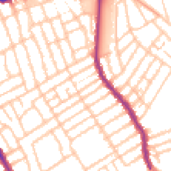
Daytime· 07:00 – 23:00
52.3dB

Everything within walking distance
Schools, transport stops and scenic spots near this property — 66 points of interest in total.
Common questions
The questions buyers, sellers and homeowners most often ask about 32 Balfour Road, Ealing, London, W13 9TN. Each answer is also embedded as structured data for search engines.
