Are you a property professional?Get qualified leads from motivated homeowners.
Get started29 Albany Road, Ealing, London, W13 8PQ
3 sales on record
About 29 Albany Road
A plain-English summary derived from public records, EPC certificates, sold prices and local data.
29 Albany Road is a four-bedroom semi-detached house in Ealing, London, London (W13 8PQ). It has a recorded floor area of 139 m² (around 1496 sq ft), construction records dating it to 1900-1929 and council tax band F. The latest certificate (March 2022) shows a C (score 69), just inside the C band. The recommended improvements would push it to B (score 85).
Sale prices here have outpaced London HPI: 9.1% per year against 0% for the wider region. On a £-per-square-foot basis, the last sale (£742/sq ft) was about 60.7% above the typical sold price in the postcode. 4 planning records sit against the property, 3 approved, 0 refused. Past consents include a loft conversion and an extension, meaningful when judging how the property has evolved. At 139 m² it's 17.6% larger than the typical home in the postcode (118 m² median across 23 EPCs). Its energy rating outperforms most of the postcode (better than 87% of similar EPCs). Most recent transfer: June 2022 at £1,110,000. That sale was during the post-pandemic price surge, when transactions cleared materially above pre-2020 trend.
What this property has
Pulled from EPC certificates, claim submissions and our property model. Empty categories are hidden — we only show what's known.
Inside
- Bedrooms4
- Bathrooms3
- Open-plan layoutYes
- EnsuiteYes
Energy performance
Every EPC certificate filed against this property — current rating, recorded improvements, and where there's headroom to reach a higher band.
EPC Rating
A
B
C
C69
D
E
F
G
Main Heating
Gas
Main Fuel
Gas
Hot Water
Good
Windows
Good
CO2 Emissions
4.4 t/year
Occupancy
Owner Occupied
Planning history
Applications and permits filed against 29 Albany Road, Ealing, London, W13 8PQ, sourced from the PlanIt planning register.
Planning history includes both a loft conversion and an extension — the classic family-home expansion.
- Sept 2013Loft ConversionOutlineGranted
Rear roof extension (involving conversion of roofspace into habitable use) and installation of three rooflights to front roofslope (Lawful Development Certificate for a Proposed Development)
Sales history & valuation
Recorded transactions, our model's current estimate, and a quick read on what neighbouring properties have sold for.
29 Albany Road has more than quadrupled in price since its earliest registered sale in 1996.
Current estimate
See how we calculated this£1,149,000
Modelled from EPC, postcode comparables and a sale-price growth of 9.1% per year over 26 years.
Last sold (2022)
£1,110,000
Growth on file: 9.1% per year over 26 years.
Sales timeline
Launch offer · 33% off
The complete analysis of 29 Albany Road, Ealing, London, W13 8PQ
Everything we know about this property, compiled into one in-depth, downloadable report.
Detailed AI analysis
An AI-written breakdown of everything that matters
Versus other Albany Road homes
Four headline reads against 20 similar houses on this street, drawn from the latest EPC and Land Registry data.
29 Albany Road outperforms the street on price per m² by a wide margin.
Price per m²
£7,986
Street avg £6,928
Floor Area
139 m²
Street avg 126 m²
Habitable Rooms
6 rooms
Similar properties nearby
A handful of close matches in the same postcode area, ranked by likeness on bedrooms, type and floor area.
The neighbourhood at a glance
A condensed read of the local area. Each tile links through to the full breakdown on the London district page.
Rail-style transport is unusually close for this postcode.
Crime
4/mo
Rising year-on-year across the wider district.
Nearest stop
0.1 km
The Avenue (W13) — bus stop.
Road noise across the postcode
Modelled day and night-time noise levels around W13 8PQ from Defra's strategic mapping. The pin marks this postcode's centroid.
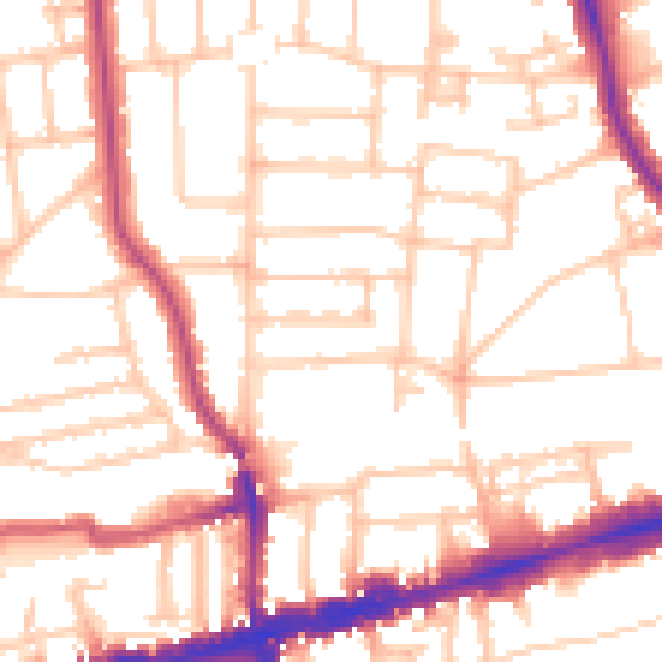
Daytime· 07:00 – 23:00
53.1dB

Everything within walking distance
Schools, transport stops and scenic spots near this property — 68 points of interest in total.
Common questions
The questions buyers, sellers and homeowners most often ask about 29 Albany Road, Ealing, London, W13 8PQ. Each answer is also embedded as structured data for search engines.
