Are you a property professional?Get qualified leads from motivated homeowners.
Get started28 Burniston Drive, Billingham, TS22 5DD
1 planning record
About 28 Burniston Drive
A plain-English summary derived from public records, EPC certificates, sold prices and local data.
28 Burniston Drive is a four-bedroom semi-detached house in Billingham (TS22 5DD). It has a recorded floor area of 100 m² (around 1076 sq ft), construction records dating it to 1967-1975 and council tax band C. The latest certificate (March 2024) shows a D (score 66), on the cusp of jumping into the C band. The recommended improvements would push it to C (score 80). The home occupies a corner plot.
On a £-per-square-foot basis, the last sale (£186/sq ft) was about 36.7% above the typical sold price in the postcode. Sold May 2024 for £200,000. One historical planning record sits against the property in 2025.
What this property has
Pulled from EPC certificates, claim submissions and our property model. Empty categories are hidden — we only show what's known.
Inside
- Bedrooms4
- Bathrooms2
- Dining roomYes
Outside
- Private garden
Energy performance
Every EPC certificate filed against this property — current rating, recorded improvements, and where there's headroom to reach a higher band.
EPC Rating
A
B
C
D
D66
E
F
G
Main Heating
Gas
Main Fuel
Gas
Hot Water
Good
Windows
Average
CO2 Emissions
4.0 t/year
Occupancy
Owner Occupied
Planning history
Applications and permits filed against 28 Burniston Drive, Billingham, TS22 5DD, sourced from the PlanIt planning register.
A recent planning application at 28 Burniston Drive was refused — worth checking the council file.
- Oct 2025AmendmentRefused
Change of use from open space to residential garden to include the relocation of the existing 1.8m metre boundary fence.
Sales history & valuation
Recorded transactions, our model's current estimate, and a quick read on what neighbouring properties have sold for.
Latest sale on 28 Burniston Drive was the highest on Land Registry record across the postcode.
Current estimate
See how we calculated this£219,000
Modelled from EPC, postcode comparables.
Last sold (2024)
£200,000
Recorded with HM Land Registry.
Sales timeline
Versus other Burniston Drive homes
Four headline reads against 7 similar houses on this street, drawn from the latest EPC and Land Registry data.
28 Burniston Drive outperforms the street on price per m² by a wide margin.
Price per m²
£2,000
Street avg £1,531
Floor Area
100 m²
Street avg 99 m²
Habitable Rooms
6 rooms
Similar properties nearby
A handful of close matches in the same postcode area, ranked by likeness on bedrooms, type and floor area.
The neighbourhood at a glance
A condensed read of the local area. Each tile links through to the full breakdown on the Billingham district page.
Crime
3/mo
Steady year-on-year across the wider district.
Nearest stop
0.1 km
The White House — bus stop.
Road noise across the postcode
Modelled day and night-time noise levels around TS22 5DD from Defra's strategic mapping. The pin marks this postcode's centroid.
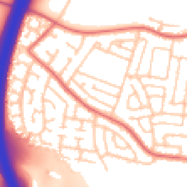
Daytime· 07:00 – 23:00
55.3dB

Everything within walking distance
Schools, transport stops and scenic spots near this property — 47 points of interest in total.
Beautiful places to visit nearby
Curated scenic spots within reach of this postcode, served by Beautifulplaces.ai. Photography and tagging come from their open dataset.
Common questions
The questions buyers, sellers and homeowners most often ask about 28 Burniston Drive, Billingham, TS22 5DD. Each answer is also embedded as structured data for search engines.