39 Kemberton Drive, Madeley, Telford, TF7 4EL
5 sales on record
About 39 Kemberton Drive
A plain-English summary derived from public records, EPC certificates, sold prices and local data.
39 Kemberton Drive is a four-bedroom semi-detached house in Madeley, Telford, Telford (TF7 4EL). It has a recorded floor area of 93 m² (around 1001 sq ft), construction records dating it to 1950-1966 and council tax band B. The latest certificate (April 2017) shows a D (score 61), on the cusp of jumping into the C band. The recommended improvements would lift it to B (score 84), a 2-band jump.
Sale prices here have outpaced England HPI: 7% per year against 0% for the wider region. On a £-per-square-foot basis, the last sale (£216/sq ft) was about 46.9% above the typical sold price in the postcode. At 93 m² it's 20.8% larger than the typical home in the postcode (77 m² median across 11 EPCs). Most recent transfer: May 2022 at £216,000. That sale was during the post-pandemic price surge, when transactions cleared materially above pre-2020 trend.
Before you offer
Know exactly what you're buying at 39 Kemberton Drive
Before you offer, see what the listing won't tell you, the true value, the red flags and the full history.
£9.99£14.99
Launch offer · save £5
What this property has
Pulled from EPC certificates, claim submissions and our property model. Empty categories are hidden — we only show what's known.
Inside
- Bedrooms4
- Bathrooms1
- EnsuiteYes
- StudyYes
Energy performance
Every EPC certificate filed against this property — current rating, recorded improvements, and where there's headroom to reach a higher band.
Recommended upgrades on file would lift this property by multiple EPC bands.
EPC Rating
A
B
C
D
D61
E
F
G
Main Heating
Gas
Main Fuel
Gas
Hot Water
Average
Windows
Average
CO2 Emissions
4.9 t/year
Occupancy
Owner Occupied
Planning history
Applications and permits filed against 39 Kemberton Drive, Madeley, Telford, TF7 4EL, sourced from the PlanIt planning register.
39 Kemberton Drive has no planning applications on record.
Notable planning nearby
3applications of note in the surrounding area
Sales history & valuation
Recorded transactions, our model's current estimate, and a quick read on what neighbouring properties have sold for.
Latest sale on 39 Kemberton Drive was the highest on Land Registry record across the postcode.
Current estimate
See how we calculated this£237,000
Modelled from EPC, postcode comparables and a sale-price growth of 7.0% per year over 26 years.
Last sold (2022)
£216,000
Growth on file: 7.0% per year over 26 years.
Sales timeline
Before you offerLaunch offer · save £5
Everything we know about 39 Kemberton Drive, in one report
What it's really worth, what could be wrong, and the planning, sales and area data in full.
- Am I paying too much?
- Is something wrong with it?
Versus other Kemberton Drive homes
Four headline reads against 11 similar houses on this street, drawn from the latest EPC and Land Registry data.
CO₂ Emissions for 39 Kemberton Drive lags the street by a wide margin.
Price per m²
£2,323
Street avg £1,582
Floor Area
93 m²
Street avg 77 m²
Habitable Rooms
7 rooms
Similar properties nearby
A handful of close matches in the same postcode area, ranked by likeness on bedrooms, type and floor area.
The neighbourhood at a glance
A condensed read of the local area. Each tile links through to the full breakdown on the Telford district page.
Reported crime in the wider district is trending notably upward year-on-year.
Crime
5/mo
Rising year-on-year across the wider district.
Nearest stop
0.1 km
Kemberton Drive — bus stop.
Road noise across the postcode
Modelled day and night-time noise levels around TF7 4EL from Defra's strategic mapping. The pin marks this postcode's centroid.
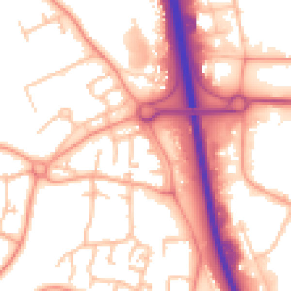
Daytime· 07:00 – 23:00
55.8dB

Everything within walking distance
Schools, transport stops and scenic spots near this property — 44 points of interest in total.
Common questions
The questions buyers, sellers and homeowners most often ask about 39 Kemberton Drive, Madeley, Telford, TF7 4EL. Each answer is also embedded as structured data for search engines.
