53a, Crewe Road, Alsager, Stoke On Trent, ST7 2EY
About 53a
53a is a property in Alsager, Stoke-On-Trent, Stoke On Trent (ST7 2EY). It has council tax band A.
Held since August 2007 — that's 19 years off the open market, well above the local norm. That sale landed at the peak of the pre-credit-crunch market, which is a useful reference point when interpreting the price. Across 2004–2007, sale prices on this property compounded at 1.7% per year.
Everything you need to know about 53a
The true value, the hidden risks and the full sale history, in one report.
30-day money-back guarantee

The data behind every report


Energy performance
No EPC on record
This property doesn't have an Energy Performance Certificate yet. An EPC is required to sell or let — and unlocks our automated valuation.
Planning history
53a has no planning applications on record.
Notable planning nearby
1applications of note in the surrounding area
We flagged 1 thing worth checking at 53a
Independent checks surfaced things a buyer would want to understand before offering. The report explains each one in full, with the underlying data and what to ask.
- Larger development activity nearby
30-day money-back guarantee
Sales history & valuation
The latest sale landed at the peak of the pre-credit-crunch market — a high-water reference point.
£130,000
Growth on file: 1.7% per year over 3 years.
Sales timeline
23 August 2007Most recent
£130,000
+5.7%over 3 years25 May 2004
£123,000
Median price across the last 5 sales in ST7 2EY: £510,000 (2024–2022).
Nearby sales in ST7 2EY
37 Crewe Road, Alsager, Stoke On Trent, ST7 2EY
Sold Oct 2024
£690,000Holly Villa, 27 Crewe Road, Alsager, Stoke On Trent, ST7 2EY
Sold Feb 2024
£290,00053 Crewe Road, Alsager, Stoke On Trent, ST7 2EY
Sold Mar 2023
£158,00039 Crewe Road, Alsager, Stoke On Trent, ST7 2EY
Sold Feb 2023
£550,00043 Crewe Road, Alsager, Stoke On Trent, ST7 2EY
Sold Jun 2022
£510,000
Everything you need to know about 53a
The true value, the hidden risks and the full sale history, in one report.
30-day money-back guarantee
The data behind every report
Similar properties nearby
1 Beeston Drive, Alsager
ST7 2XE
1 Barn Field Way, Alsager
ST7 2GZ
1 Bluebell Way, Alsager
ST7 2GG
1 Berkeley Avenue, Alsager
ST7 2BW
1 Bainbridge Street, Alsager
ST7 2FH
1 Band Drive, Alsager
ST7 2WD
1 Bailey Court, Alsager
ST7 2YH
1 Ashmores Lane, Alsager
ST7 2LN
The neighbourhood at a glance
Rail-style transport is unusually close for this postcode.
Crime
3/mo
Steady year-on-year across the wider district.
Nearest stop
0.0 km
Police Station — bus stop.
Closest school
0.3 km
St Gabriel's Catholic Primary School. 7 schools nearby.
Go deeper on the local area
The full report breaks down crime, transport links, schools and air quality in depth.
Road noise across the postcode
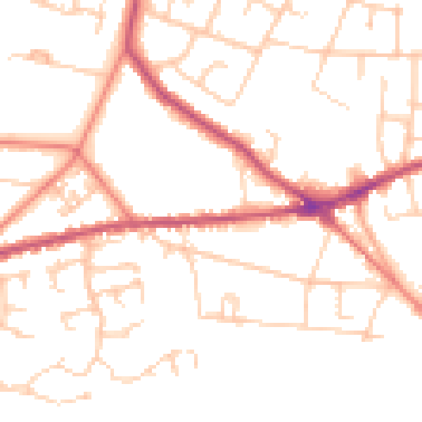
Daytime· 07:00 – 23:00
50.4dB

Night-time· 23:00 – 07:00
40.4dB