203 Bitterne Road West, Southampton, SO18 1BL
About 203 Bitterne Road West
203 Bitterne Road West is a semi-detached house in Southampton (SO18 1BL). It has a recorded floor area of 121 m² (around 1302 sq ft), construction records dating it to 1900-1929 and council tax band C. The latest certificate (June 2023) shows a D (score 61), on the cusp of jumping into the C band. The recommended improvements would push it to C (score 77).
At 121 m² the property is well over the postcode median (68 m² across 18 EPCs), placing it in the larger end of the local stock. One historical planning record sits against the property in 2006.
Everything you need to know about 203 Bitterne Road West
The true value, the hidden risks and the full sale history, in one report.
30-day money-back guarantee

The data behind every report


Energy performance
EPC Rating
Planning history
- Apr 2006Change Of UseFullIn report
Change of use of part ground floor from residential and retail use (Use Class A1) to use for off-site commercial catering food preparation activity (Use Class B1) and associated hot food takeaway use (Use Class A5)
- Documents
- 10 docs on file
- Reference
- 05/01746/FUL
We flagged 1 thing worth checking at 203 Bitterne Road West
Independent checks surfaced things a buyer would want to understand before offering. The report explains each one in full, with the underlying data and what to ask.
- Signs of HMO activity in the area
30-day money-back guarantee
Sales history & valuation
203 Bitterne Road West has no Land Registry sales on file, suggesting it has stayed in the same hands since registration began.
£347,000
Modelled from EPC, postcode comparables.
No sales recorded with HM Land Registry
That can mean the property has never traded since the registry began publishing in 1995, was a new build that hasn't been registered yet, or is held in the same hands long-term.
Median price across the last 5 sales in SO18 1BL: £212,000 (2025–2014).
Nearby sales in SO18 1BL
217a, Bitterne Road West, Southampton, SO18 1BL
Sold Mar 2025
£143,600197 Bitterne Road West, Southampton, SO18 1BL
Sold Dec 2022
£450,000195 Bitterne Road West, Southampton, SO18 1BL
Sold Oct 2015
£275,000215 Bitterne Road West, Southampton, SO18 1BL
Sold Jul 2014
£212,000193 Bitterne Road West, Southampton, SO18 1BL
Sold Jun 2009
£215,000
Versus other Bitterne Road West homes
EPC Rating
61 (D)
Street avg 60 (D)
Floor Area
121 m²
Street avg 127 m²
CO₂ Emissions
5.1 t/year
Street avg 5.0 t/year
Habitable Rooms
7 rooms
Street avg 6 rooms
Everything you need to know about 203 Bitterne Road West
The true value, the hidden risks and the full sale history, in one report.
30-day money-back guarantee
The data behind every report
Similar properties nearby
The neighbourhood at a glance
Rail-style transport is unusually close for this postcode.
Crime
6/mo
Rising year-on-year across the wider district.
Nearest stop
0.0 km
Midanbury Lane — bus stop.
Closest school
0.3 km
Beechwood Junior School. 36 schools nearby.
Go deeper on the local area
The full report breaks down crime, transport links, schools and air quality in depth.
Road noise across the postcode
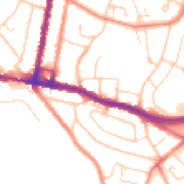
Daytime· 07:00 – 23:00
51.3dB
Night-time· 23:00 – 07:00
41.6dB