8 Manley Road, Gawsworth, Macclesfield, SK11 7UU
About 8 Manley Road
8 Manley Road is a four-bedroom semi-detached house in Gawsworth, Macclesfield, Macclesfield (SK11 7UU). It has a recorded floor area of 98 m² (around 1055 sq ft), construction records dating it to 1967-1975 and council tax band D. The latest certificate (March 2024) shows a D (score 59), a step below the typical UK home. The recommended improvements would push it to C (score 75).
Today's modelled estimate of £345,000 is 17.5% above the 2024 sale price. On a £-per-square-foot basis, the last sale (£278/sq ft) was about 59.9% above the typical sold price in the postcode. Sold May 2024 for £293,500.
What this property has
Inside
- Bedrooms4
- Bathrooms1
Everything you need to know about 8 Manley Road
The true value, the hidden risks and the full sale history, in one report.
30-day money-back guarantee

The data behind every report


Energy performance
EPC Rating
Planning history
8 Manley Road has no planning applications on record.
Notable planning nearby
3applications of note in the surrounding area
We flagged 1 thing worth checking at 8 Manley Road
Independent checks surfaced things a buyer would want to understand before offering. The report explains each one in full, with the underlying data and what to ask.
- Larger development activity nearby
30-day money-back guarantee
Sales history & valuation
Latest sale on 8 Manley Road was the highest on Land Registry record across the postcode.
£345,000
Modelled from EPC, postcode comparables.
£293,500
Recorded with HM Land Registry.
Sales timeline
30 May 2024Most recent
£293,500
Median price across the last 5 sales in SK11 7UU: £200,000 (2016–2010).
Nearby sales in SK11 7UU
7 Manley Road, Gawsworth, Macclesfield, SK11 7UU
Sold Jul 2016
£235,0004 Manley Road, Gawsworth, Macclesfield, SK11 7UU
Sold Jul 2014
£195,0001 Manley Road, Gawsworth, Macclesfield, SK11 7UU
Sold Jul 2014
£202,0003 Manley Road, Gawsworth, Macclesfield, SK11 7UU
Sold Aug 2010
£200,0006 Manley Road, Gawsworth, Macclesfield, SK11 7UU
Sold Apr 1999
£96,500
Versus other Manley Road homes
On price per m², 8 Manley Road stands well clear of the street.
Price per m²
£2,995
Street avg £1,676
Floor Area
98 m²
Street avg 114 m²
Habitable Rooms
6 rooms
Street avg 6 rooms
CO₂ Emissions
5.3 t/year
Street avg 5.4 t/year
Everything you need to know about 8 Manley Road
The true value, the hidden risks and the full sale history, in one report.
30-day money-back guarantee
The data behind every report
Similar properties nearby
The neighbourhood at a glance
Crime
6/mo
Steady year-on-year across the wider district.
Nearest stop
0.1 km
Thornton Square — bus stop.
Closest school
0.2 km
Ivy Bank Primary School. 18 schools nearby.
Go deeper on the local area
The full report breaks down crime, transport links, schools and air quality in depth.
Road noise across the postcode
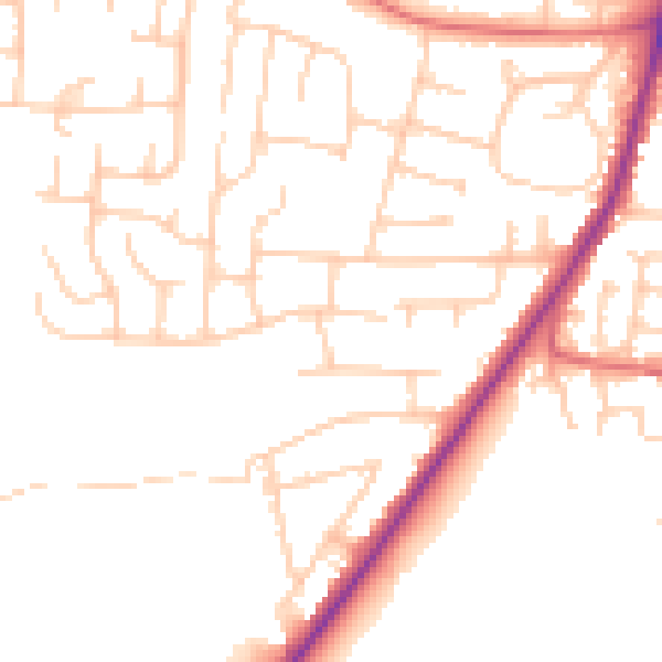
Daytime· 07:00 – 23:00
50.0dB

Night-time· 23:00 – 07:00
40.4dB