14 Cantley Gardens, Croydon, London, SE19 2SD
About 14 Cantley Gardens
A plain-English summary derived from public records, EPC certificates, sold prices and local data.
14 Cantley Gardens is a three-bedroom end-of-terrace house in Croydon, London, London (SE19 2SD). It has a recorded floor area of 82 m² (around 883 sq ft), construction records dating it to 1967-1975 and council tax band C. The latest certificate (September 2015) shows a D (score 59), a step below the typical UK home. Earlier certificates rated it C (March 2010); the latest reading is one band lower. Between certificates, lighting went from Poor to Very Good; while wall efficiency dropped from Average to Poor and roof efficiency dropped from Average to Very Poor. The recommended improvements would push it to C (score 72). The latest certificate is from September 2015, so improvements made since then won't be reflected.
It hasn't traded since August 1999, a hold of 27 years that's notably long for the area. Only one transfer is on record with HM Land Registry, suggesting it has stayed in the same hands for a long time. Today's modelled estimate of £382,000 sits 389.7% above the 1999 sale of £78,000. On a £-per-square-foot basis, the last sale (£88/sq ft) was about 67.1% below the postcode norm.
What this property has
Pulled from EPC certificates, claim submissions and our property model. Empty categories are hidden — we only show what's known.
Inside
- Bedrooms3
- Bathrooms1
Energy performance
Every EPC certificate filed against this property — current rating, recorded improvements, and where there's headroom to reach a higher band.
EPC Expired
This certificate is over 10 years old and is no longer valid.Expired 03 Sept 2025
Current Certificate(1 of 2)
Sept 2015
EPC Rating
A
B
C
D
D59
E
F
G
Main Heating
Gas
Main Fuel
Gas
Hot Water
Good
Windows
Average
CO2 Emissions
4.1 t/year
Occupancy
Owner Occupied
Planning history
Applications and permits filed against 14 Cantley Gardens, Croydon, London, SE19 2SD, sourced from the PlanIt planning register.
No planning applications are recorded against 14 Cantley Gardens, Croydon, London, SE19 2SD. The full report also covers planning activity across the surrounding area.
Full planning data for 14 Cantley Gardens, Croydon, London, SE19 2SD
Every application and decision on this property and nearby, in full, in the report.
Sales history & valuation
Recorded transactions, our model's current estimate, and a quick read on what neighbouring properties have sold for.
14 Cantley Gardens's modelled value sits at over four times its earliest registered sale price (1999).
Current estimate
See how we calculated this£382,000
Modelled from EPC, postcode comparables.
Last sold (1999)
£78,000
Recorded with HM Land Registry.
Sales timeline
Launch offer · 33% off
The complete analysis of 14 Cantley Gardens, Croydon, London, SE19 2SD
Everything we know about this property, compiled into one in-depth, downloadable report.
Detailed analysis
A written breakdown of everything that matters
Versus other Cantley Gardens homes
Four headline reads against 7 similar flats on this street, drawn from the latest EPC and Land Registry data.
Price per m² for 14 Cantley Gardens lags the street by a wide margin.
Price per m²
£951
Street avg £4,241
Floor Area
82 m²
Street avg 89 m²
Habitable Rooms
5 rooms
Similar properties nearby
A handful of close matches in the same postcode area, ranked by likeness on bedrooms, type and floor area.
The neighbourhood at a glance
A condensed read of the local area. Each tile links through to the full breakdown on the London district page.
Rail-style transport is unusually close for this postcode.
Crime
5/mo
Steady year-on-year across the wider district.
Nearest stop
0.1 km
Harris City Academy — bus stop.
Road noise across the postcode
Modelled day and night-time noise levels around SE19 2SD from Defra's strategic mapping. The pin marks this postcode's centroid.
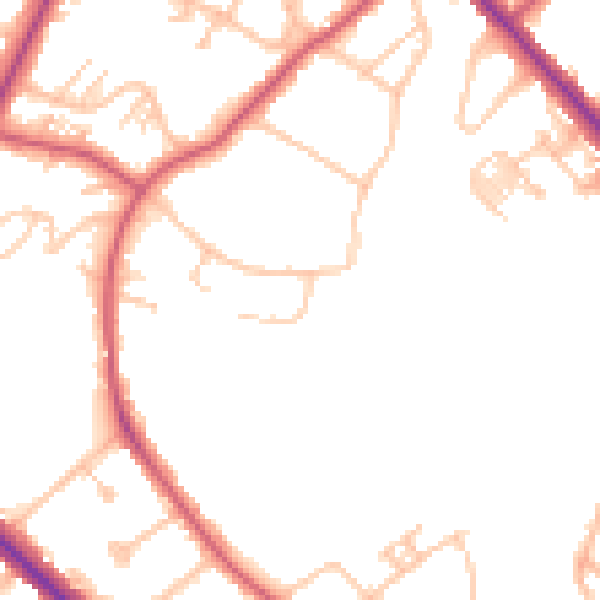
Daytime· 07:00 – 23:00
48.3dB

Everything within walking distance
Schools, transport stops and scenic spots near this property — 91 points of interest in total.
Common questions
The questions buyers, sellers and homeowners most often ask about 14 Cantley Gardens, Croydon, London, SE19 2SD. Each answer is also embedded as structured data for search engines.
