43 Kinglake Street, Southwark, London, SE17 2RR
About 43 Kinglake Street
43 Kinglake Street is a four-bedroom end-of-terrace house in Southwark, London, London (SE17 2RR). It has a recorded floor area of 83 m² (around 893 sq ft), construction records dating it to 1976-1982 and council tax band C. The latest certificate (February 2025) shows a C (score 75), near the top of the C band. When first surveyed in November 2012 the rating was D, the property has climbed 1 band since. Between certificates, roof efficiency went from Very Poor to Poor, window efficiency went from Average to Good and lighting went from Very Poor to Very Good. At 83 m² this is the 16th smallest of 19 units on EPC record in the building, where floor areas span 49–96 m². The building's EPC ratings span E to B across 19 units on file.
At 83 m² the property is well over the postcode median (50 m² across 18 EPCs), placing it in the larger end of the local stock. Today's modelled estimate of £418,000 sits 77.9% above the 2013 sale of £235,000. On the market in June 2013 and unlisted since — roughly 13 years.
Know exactly what you're buying at 43 Kinglake Street
Before you offer, see what the listing won't tell you, the true value, the red flags and the full history.
Already flagged here
Launch offer · save £5
Valuation
against the asking price
Risks
planning & flood
Sold prices
similar homes nearby
Trends
the local market
What this property has
Inside
- Bedrooms4
- Bathrooms2
Energy performance
EPC Rating
Property Improvements
Changes detected from historical EPC data
Window efficiency improved
Roof insulation improved
More low energy lighting installed
Planning history
43 Kinglake Street has no planning applications on record.
Notable planning nearby
4applications of note in the surrounding area
We flagged 1 thing worth checking at 43 Kinglake Street
Independent checks surfaced things a buyer would want to understand before offering. The report explains each one in full, with the underlying data and what to ask.
- Signs of HMO activity in the area
30-day money-back guarantee
Sales history & valuation
43 Kinglake Street valuation sits well clear of the typical sold price in this postcode.
£418,000
Modelled from EPC, postcode comparables.
£235,000
Recorded with HM Land Registry.
Sales timeline
11 June 2013Most recent
£235,000
Median price across the last 5 sales in SE17 2RR: £140,000 (2024–2009).
Nearby sales in SE17 2RR
15 Kinglake Street, Southwark, London, SE17 2RR
Sold Jul 2024
£250,00017 Kinglake Street, Southwark, London, SE17 2RR
Sold Jan 2014
£165,00031 Kinglake Street, Southwark, London, SE17 2RR
Sold Feb 2013
£140,00011 Kinglake Street, Southwark, London, SE17 2RR
Sold Nov 2012
£135,00037 Kinglake Street, Southwark, London, SE17 2RR
Sold Jun 2007
£245,000
Everything we know about 43 Kinglake Street, in one report
What it's really worth, what could be wrong, and the planning, sales and area data in full.
What we flagged
- Signs of HMO activity in the area

Versus other Kinglake Street homes
Habitable Rooms for 43 Kinglake Street runs comfortably ahead of the street norm.
Price per m²
£2,831
Street avg £3,290
Floor Area
83 m²
Street avg 60 m²
Habitable Rooms
5 rooms
Street avg 3 rooms
CO₂ Emissions
2.2 t/year
Street avg 2.6 t/year
Similar properties nearby
1 Wooler Street, Southwark
SE17 2ED
1 Aylesbury Road, Southwark
SE17 2EQ
1 Aycliffe House, Portland Street, Southwark
SE17 2PE
1 Liverpool Grove, Southwark
SE17 2HW
1 John Crane Street, Southwark
SE17 2FQ
1 Exon Street, Southwark
SE17 2JW
1 Baillie House, Horsley Street, Southwark
SE17 2AT
1 Strathcona House, Horsley Street, Southwark
SE17 2AS
The neighbourhood at a glance
Reported crime in the wider district is trending notably upward year-on-year.
Crime
19/mo
Rising year-on-year across the wider district.
Nearest stop
0.1 km
Dunton Road — bus stop.
Closest school
0.1 km
Ark Walworth Academy. 102 schools nearby.
Go deeper on the local area
The full report breaks down crime, transport links, schools and air quality in depth.
Road noise across the postcode
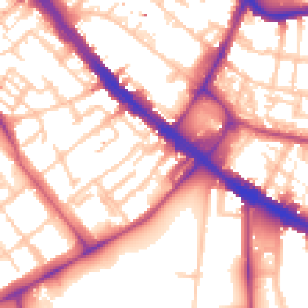
Daytime· 07:00 – 23:00
56.7dB

Night-time· 23:00 – 07:00
46.3dB