9 Lanvanor Road, Southwark, London, SE15 2BT
About 9 Lanvanor Road
9 Lanvanor Road is a three-bedroom mid-terrace house in Southwark, London, London (SE15 2BT). It has a recorded floor area of 102 m² (around 1098 sq ft), construction records dating it to 1900-1929 and council tax band D. The property has underfloor heating on record, all of which lower running costs and tend to lift resale appeal. Other recorded features include a basement. Period features are noted in the property record. Our model identifies extension potential, subject to local planning policy. The latest certificate (September 2025) shows a D (score 66), on the cusp of jumping into the C band. The rating has held steady at D across 2 certificates since September 2012. Between certificates, wall efficiency went from Very Poor to Poor; while roof efficiency dropped from Good to Average. The recommended improvements would push it to C (score 76).
Across 1998–2017, sale prices on this property compounded at 11.9% per year. Today's modelled estimate of £989,000 is 30.1% above the 2017 sale price. On a £-per-square-foot basis, the last sale (£692/sq ft) was about 80.8% above the typical sold price in the postcode. On the market in September 2017 and unlisted since — roughly 9 years.
Know exactly what you're buying at 9 Lanvanor Road
Before you offer, see what the listing won't tell you, the true value, the red flags and the full history.
Already flagged here
Launch offer · save £5
Valuation
against the asking price
Risks
planning & flood
Sold prices
similar homes nearby
Trends
the local market
What this property has
Inside
- Bedrooms3
- Bathrooms1
- BasementYes
Outside
- Private gardenYes
- Parkingoff_street
Building
- Underfloor heatingYes
- Period featuresYes
- RefurbishedYes
- Extension potentialPossible
Energy performance
EPC Rating
Property Improvements
Changes detected from historical EPC data
Heating controls upgraded for better temperature management
Windows upgraded, improving insulation
Wall insulation improved
Planning history
9 Lanvanor Road has no planning applications on record.
Notable planning nearby
4applications of note in the surrounding area
We flagged 1 thing worth checking at 9 Lanvanor Road
Independent checks surfaced things a buyer would want to understand before offering. The report explains each one in full, with the underlying data and what to ask.
- Signs of HMO activity in the area
30-day money-back guarantee
Sales history & valuation
9 Lanvanor Road has more than quadrupled in price since its earliest registered sale in 1998.
£989,000
Modelled from EPC, postcode comparables and a sale-price growth of 11.9% per year over 19 years.
£760,000
Growth on file: 11.9% per year over 19 years.
Sales timeline
7 September 2017Most recent
£760,000
+176.4%over 11 years24 January 2006
£275,000
+198.9%over 7 years20 November 1998
£92,000
Median price across the last 5 sales in SE15 2BT: £850,000 (2025–2021).
Nearby sales in SE15 2BT
17a, Lanvanor Road, Southwark, London, SE15 2BT
Sold Nov 2025
£450,00029 Lanvanor Road, Southwark, London, SE15 2BT
Sold Sept 2024
£946,5005 Lanvanor Road, Southwark, London, SE15 2BT
Sold Dec 2023
£880,00043 Lanvanor Road, Southwark, London, SE15 2BT
Sold Oct 2022
£530,00011 Lanvanor Road, Southwark, London, SE15 2BT
Sold Sept 2021
£850,000
Everything we know about 9 Lanvanor Road, in one report
What it's really worth, what could be wrong, and the planning, sales and area data in full.
What we flagged
- Signs of HMO activity in the area

Versus other Lanvanor Road homes
9 Lanvanor Road outperforms the street on co₂ emissions by a wide margin.
Price per m²
£7,451
Street avg £6,531
Floor Area
102 m²
Street avg 107 m²
Habitable Rooms
6 rooms
Street avg 5 rooms
CO₂ Emissions
3.3 t/year
Street avg 4.1 t/year
Similar properties nearby
1 Brabourn Grove, Southwark
SE15 2BS
1 Hathorne Close, Southwark
SE15 2BY
1 King Arthur Close, Southwark
SE15 2LP
1 Dayton Grove, Southwark
SE15 2NX
1 Lanvanor Road, Southwark
SE15 2BT
1 Glenton Mews, Southwark
SE15 2EH
1 Kings Grove, Southwark
SE15 2LY
1 Lulworth Road, Southwark
SE15 2BL
The neighbourhood at a glance
Rail-style transport is unusually close for this postcode.
Crime
11/mo
Rising year-on-year across the wider district.
Nearest stop
0.2 km
Hollydale Road — bus stop.
Closest school
0.2 km
The St Thomas the Apostle College. 81 schools nearby.
Go deeper on the local area
The full report breaks down crime, transport links, schools and air quality in depth.
Road noise across the postcode
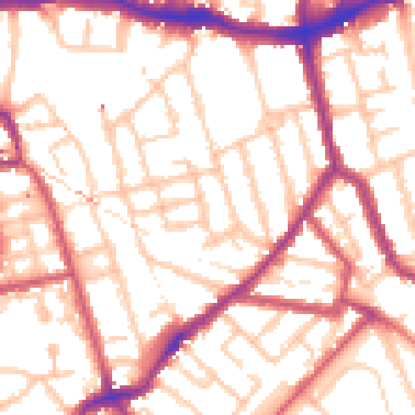
Daytime· 07:00 – 23:00
54.3dB

Night-time· 23:00 – 07:00
43.7dB