3 Beckett Hospital Terrace, Barnsley, S70 4JP
About 3 Beckett Hospital Terrace
3 Beckett Hospital Terrace is a mid-terrace house in Barnsley (S70 4JP). It has a recorded floor area of 56 m² (around 603 sq ft), construction records dating it to 1900-1929 and council tax band A. The latest certificate (February 2024) shows a D (score 60), on the cusp of jumping into the C band. The rating has held steady at D across 2 certificates since April 2012. Between certificates, roof efficiency dropped from Very Good to Very Poor. The recommended improvements would push it to C (score 80).
Today's modelled estimate of £116,000 sits 251.5% above the 2018 sale of £33,000. Last sale on file: £33,000 in June 2018.
Know exactly what you're buying at 3 Beckett Hospital Terrace
Before you offer, see what the listing won't tell you, the true value, the red flags and the full history.
Already flagged here
Valuation
against the asking price
Risks
planning & flood
Sold prices
similar homes nearby
Trends
the local market
Energy performance
EPC Rating
Property Improvements
Changes detected from historical EPC data
More low energy lighting installed
Planning history
3 Beckett Hospital Terrace has no planning applications on record.
Notable planning nearby
7applications of note in the surrounding area
We flagged 2 things worth checking at 3 Beckett Hospital Terrace
Independent checks surfaced things a buyer would want to understand before offering. The report explains each one in full, with the underlying data and what to ask.
- Signs of HMO activity in the area
- Larger development activity nearby
30-day money-back guarantee
Sales history & valuation
3 Beckett Hospital Terrace's estimated value is more than triple its earliest registered sale price (2018).
£116,000
Modelled from EPC, postcode comparables.
£33,000
Recorded with HM Land Registry.
Sales timeline
21 June 2018Most recent
£33,000
Median price across the last 2 sales in S70 4JP: £48,975 (2019–2005).
Everything we know about 3 Beckett Hospital Terrace, in one report
What it's really worth, what could be wrong, and the planning, sales and area data in full.
What we flagged
- Signs of HMO activity in the area
- Larger development activity nearby

Similar properties nearby
The neighbourhood at a glance
Reported crime in the wider district is trending notably upward year-on-year.
Crime
5/mo
Rising year-on-year across the wider district.
Nearest stop
0.2 km
Sheffield Road/Park Road — bus stop.
Closest school
0.4 km
Oakwell Rise Primary Academy. 23 schools nearby.
Go deeper on the local area
The full report breaks down crime, transport links, schools and air quality in depth.
Road noise across the postcode
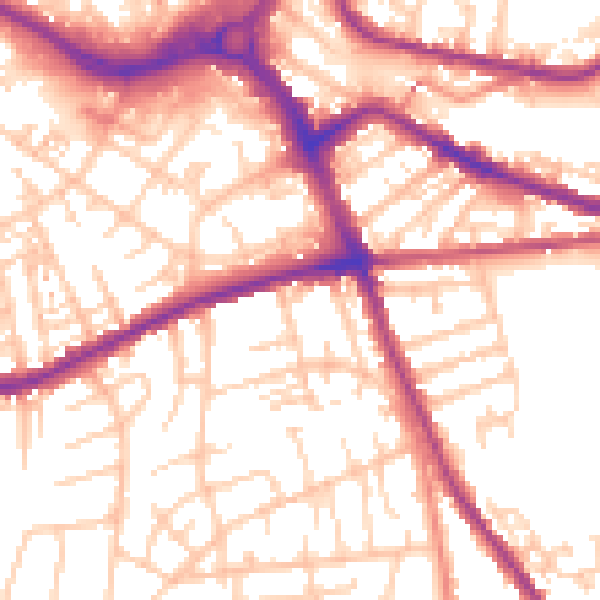
Daytime· 07:00 – 23:00
55.3dB

Night-time· 23:00 – 07:00
45.5dB