85 Blair Athol Road, Sheffield, S11 7GA
About 85 Blair Athol Road
85 Blair Athol Road is a mid-terrace house in Sheffield (S11 7GA). It has a recorded floor area of 93 m² (around 1001 sq ft), construction records dating it to 1900-1929 and council tax band B. The latest certificate (March 2022) shows a D (score 59), a step below the typical UK home. When first surveyed in January 2017 the rating was E, the property has climbed 1 band since. Between certificates, window efficiency went from Poor to Average and lighting went from Poor to Very Good. The recommended improvements would lift it to B (score 85), a 2-band jump.
Across 1999–2024, sale prices on this property compounded at 6.6% per year. On a £-per-square-foot basis, the last sale (£320/sq ft) was about 97% above the typical sold price in the postcode. Sold July 2024 for £320,000.
Know exactly what you're buying at 85 Blair Athol Road
Before you offer, see what the listing won't tell you, the true value, the red flags and the full history.
Launch offer · save £5
Valuation
against the asking price
Risks
planning & flood
Sold prices
similar homes nearby
Trends
the local market
Energy performance
Recommended upgrades on file would lift this property by multiple EPC bands.
EPC Rating
Property Improvements
Changes detected from historical EPC data
Windows upgraded, improving insulation
More low energy lighting installed
Planning history
85 Blair Athol Road has no planning applications on record.
Notable planning nearby
1applications of note in the surrounding area
Sales history & valuation
Price for 85 Blair Athol Road has grown more than fourfold since the 1999 starting point.
£312,000
Modelled from EPC, postcode comparables and a sale-price growth of 6.6% per year over 25 years.
£320,000
Growth on file: 6.6% per year over 25 years.
Sales timeline
21 July 2024Most recent
£320,000
-1.8%over 1 year30 August 2022
£326,000
+41.1%over 2 years20 March 2020
£231,000
+10.0%over 2 years25 April 2017
£210,000
+233.3%over 18 years8 April 1999
£63,000
Median price across the last 5 sales in S11 7GA: £300,000 (2025–2024).
Nearby sales in S11 7GA
Everything we know about 85 Blair Athol Road, in one report
What it's really worth, what could be wrong, and the planning, sales and area data in full.
- Am I paying too much?
- Is something wrong with it?
- Is the agent's story true?
- Will it hold its value?

Versus other Blair Athol Road homes
Price per m² for 85 Blair Athol Road runs comfortably ahead of the street norm.
Price per m²
£3,441
Street avg £2,640
Floor Area
93 m²
Street avg 86 m²
Habitable Rooms
5 rooms
Street avg 5 rooms
CO₂ Emissions
5.0 t/year
Street avg 5.4 t/year
Similar properties nearby
The neighbourhood at a glance
Crime
2/mo
Steady year-on-year across the wider district.
Nearest stop
0.1 km
Ecclesall Road/Greystones Road — bus stop.
Closest school
0.2 km
Greystones Primary School. 33 schools nearby.
Go deeper on the local area
The full report breaks down crime, transport links, schools and air quality in depth.
Road noise across the postcode
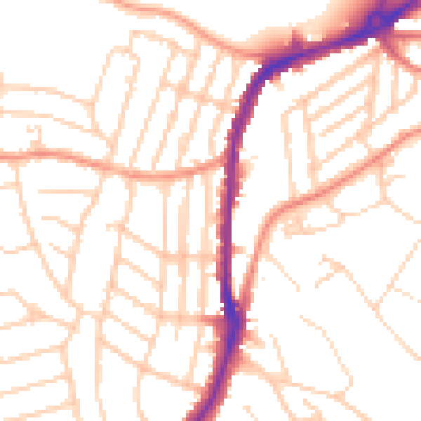
Daytime· 07:00 – 23:00
51.0dB
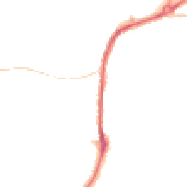
Night-time· 23:00 – 07:00
40.6dB