9 Dartmouth Walk, Basingstoke, RG22 6QU
About 9 Dartmouth Walk
9 Dartmouth Walk is an end-of-terrace house in Basingstoke (RG22 6QU). It has a recorded floor area of 96 m² (around 1033 sq ft), construction records dating it to 1967-1975 and council tax band C. The latest certificate (April 2012) shows a D (score 65), on the cusp of jumping into the C band. The recommended improvements would lift it to B (score 84), a 2-band jump. The latest certificate is from April 2012, so improvements made since then won't be reflected.
At 96 m² it's 28.9% larger than the typical home in the postcode (75 m² median across 16 EPCs).
Everything you need to know about 9 Dartmouth Walk
The true value, the hidden risks and the full sale history, in one report.
30-day money-back guarantee

The data behind every report


Energy performance
Recommended upgrades on file would lift this property by multiple EPC bands.
EPC Expired
This certificate is over 10 years old and is no longer valid.Expired 18 Apr 2022
EPC Rating
Planning history
9 Dartmouth Walk has no planning applications on record.
The full report still covers planning activity across the surrounding area.
Sales history & valuation
9 Dartmouth Walk has no Land Registry sales on file, suggesting it has stayed in the same hands since registration began.
£300,000
Modelled from EPC, postcode comparables.
No sales recorded with HM Land Registry
That can mean the property has never traded since the registry began publishing in 1995, was a new build that hasn't been registered yet, or is held in the same hands long-term.
Median price across the last 5 sales in RG22 6QU: £255,000 (2024–2017).
Nearby sales in RG22 6QU
12 Dartmouth Walk, Basingstoke, RG22 6QU
Sold Apr 2024
£295,0002 Dartmouth Walk, Basingstoke, RG22 6QU
Sold Oct 2021
£315,00015 Dartmouth Walk, Basingstoke, RG22 6QU
Sold Jun 2020
£250,0004 Dartmouth Walk, Basingstoke, RG22 6QU
Sold Dec 2018
£230,50023 Dartmouth Walk, Basingstoke, RG22 6QU
Sold May 2017
£255,000
Versus other Dartmouth Walk homes
Floor Area for 9 Dartmouth Walk runs comfortably ahead of the street norm.
EPC Rating
65 (D)
Street avg 70 (C)
Floor Area
96 m²
Street avg 79 m²
CO₂ Emissions
3.6 t/year
Street avg 2.8 t/year
Habitable Rooms
6 rooms
Street avg 4 rooms
Everything you need to know about 9 Dartmouth Walk
The true value, the hidden risks and the full sale history, in one report.
30-day money-back guarantee
The data behind every report
Similar properties nearby
The neighbourhood at a glance
Daytime road noise here sits well below conversation level — a quiet pocket of the postcode.
Crime
7/mo
Steady year-on-year across the wider district.
Nearest stop
0.2 km
Bishop Challoner Grounds — bus stop.
Closest school
0.2 km
Bishop Challoner Catholic Secondary School. 29 schools nearby.
Go deeper on the local area
The full report breaks down crime, transport links, schools and air quality in depth.
Road noise across the postcode
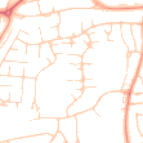
Daytime· 07:00 – 23:00
48.8dB

Night-time· 23:00 – 07:00
38.2dB