19 Ajax Street, Rochdale, OL11 3HN
About 19 Ajax Street
19 Ajax Street is a two-bedroom semi-detached house in Rochdale (OL11 3HN). It has a recorded floor area of 67 m² (around 721 sq ft), construction records dating it to 1950-1966 and council tax band A. At 67 m² this is the 13th smallest of 21 units on EPC record in the building, where floor areas span 36–95 m². The building's EPC ratings span F to C, with this unit at the top. The home occupies a cul-de-sac position. The latest certificate (August 2020) shows a C (score 69), just inside the C band.
Today's modelled estimate of £117,000 is 41% above the 2021 sale price. On a £-per-square-foot basis, the last sale (£115/sq ft) was about 18.5% above the typical sold price in the postcode. Most recent transfer: January 2021 at £83,000. That sale was during the post-pandemic price surge, when transactions cleared materially above pre-2020 trend.
What this property has
Inside
- Bedrooms2
- Bathrooms1
- EnsuiteYes
Outside
- Private gardenYes
- ParkingOff road
- Cul-de-sacYes
Everything you need to know about 19 Ajax Street
The true value, the hidden risks and the full sale history, in one report.
30-day money-back guarantee

The data behind every report


Energy performance
EPC Rating
Planning history
19 Ajax Street has no planning applications on record.
Notable planning nearby
4applications of note in the surrounding area
We flagged 1 thing worth checking at 19 Ajax Street
Independent checks surfaced things a buyer would want to understand before offering. The report explains each one in full, with the underlying data and what to ask.
- Signs of HMO activity in the area
30-day money-back guarantee
Sales history & valuation
The latest sale landed in the post-pandemic price surge — useful context when reading the figure.
£117,000
Modelled from EPC, postcode comparables.
£83,000
Recorded with HM Land Registry.
Sales timeline
29 January 2021Most recent
£83,000
Median price across the last 5 sales in OL11 3HN: £65,000 (2023–2015).
Versus other Ajax Street homes
Price per m² for 19 Ajax Street runs comfortably ahead of the street norm.
Price per m²
£1,239
Street avg £1,106
Floor Area
67 m²
Street avg 57 m²
Habitable Rooms
4 rooms
Street avg 3 rooms
CO₂ Emissions
2.9 t/year
Street avg 2.2 t/year
Everything you need to know about 19 Ajax Street
The true value, the hidden risks and the full sale history, in one report.
30-day money-back guarantee
The data behind every report
Similar properties nearby
The neighbourhood at a glance
Rail-style transport is unusually close for this postcode.
Crime
1/mo
Steady year-on-year across the wider district.
Nearest stop
0.1 km
Ivor Street — bus stop.
Closest school
0.5 km
Matthew Moss High School. 30 schools nearby.
Go deeper on the local area
The full report breaks down crime, transport links, schools and air quality in depth.
Road noise across the postcode
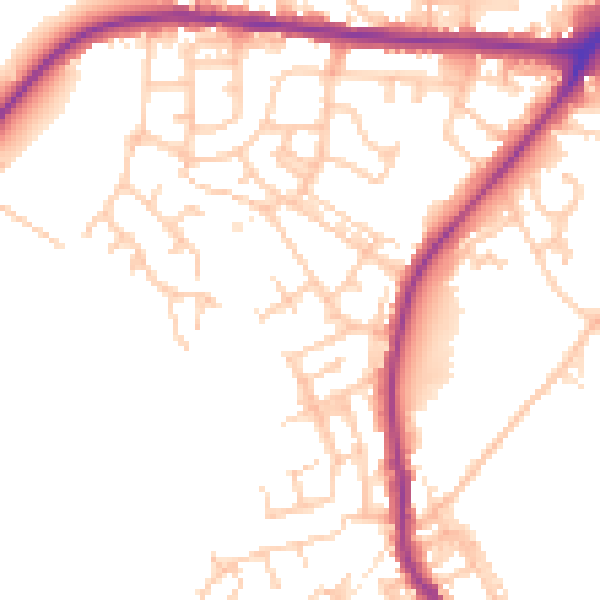
Daytime· 07:00 – 23:00
52.4dB

Night-time· 23:00 – 07:00
44.5dB