9 Beaufort Drive, Northampton, NN5 6RR
About 9 Beaufort Drive
9 Beaufort Drive is a semi-detached house in Northampton (NN5 6RR). It has a recorded floor area of 66 m² (around 710 sq ft), construction records dating it to 1976-1982 and council tax band C. The latest certificate (January 2024) shows a C (score 70). The recommended improvements would push it to B (score 86).
At 66 m² it's 16.5% smaller than the typical home in the postcode (79 m² median across 19 EPCs). Its energy rating outperforms most of the postcode (better than 74% of similar EPCs). Across 1997–2024, sale prices on this property compounded at 5.2% per year. Today's modelled estimate of £268,000 is 16.5% above the 2024 sale price. On a £-per-square-foot basis, the last sale (£324/sq ft) was about 48.3% above the typical sold price in the postcode. Last sale on file: £230,000 in May 2024.
Know exactly what you're buying at 9 Beaufort Drive
Before you offer, see what the listing won't tell you, the true value, the red flags and the full history.
Already flagged here
Valuation
against the asking price
Risks
planning & flood
Sold prices
similar homes nearby
Trends
the local market
Energy performance
EPC Rating
Planning history
9 Beaufort Drive has no planning applications on record.
Notable planning nearby
6applications of note in the surrounding area
We flagged 2 things worth checking at 9 Beaufort Drive
Independent checks surfaced things a buyer would want to understand before offering. The report explains each one in full, with the underlying data and what to ask.
- Signs of HMO activity in the area
- Larger development activity nearby
30-day money-back guarantee
Sales history & valuation
Sale price has grown by over 3x since 1997.
£268,000
Modelled from EPC, postcode comparables and a sale-price growth of 5.2% per year over 27 years.
£230,000
Growth on file: 5.2% per year over 27 years.
Sales timeline
8 May 2024Most recent
£230,000
+289.8%over 26 years6 August 1997
£59,000
Median price across the last 5 sales in NN5 6RR: £265,000 (2025–2022).
Nearby sales in NN5 6RR
Everything we know about 9 Beaufort Drive, in one report
What it's really worth, what could be wrong, and the planning, sales and area data in full.
What we flagged
- Signs of HMO activity in the area
- Larger development activity nearby

Versus other Beaufort Drive homes
On co₂ emissions, 9 Beaufort Drive stands well clear of the street.
Price per m²
£3,485
Street avg £2,960
Floor Area
66 m²
Street avg 80 m²
Habitable Rooms
3 rooms
Street avg 5 rooms
CO₂ Emissions
2.6 t/year
Street avg 3.9 t/year
Similar properties nearby
The neighbourhood at a glance
Crime
6/mo
Steady year-on-year across the wider district.
Nearest stop
0.2 km
Eldean Road — bus stop.
Closest school
0.4 km
Duston Eldean Primary School. 16 schools nearby.
Go deeper on the local area
The full report breaks down crime, transport links, schools and air quality in depth.
Road noise across the postcode
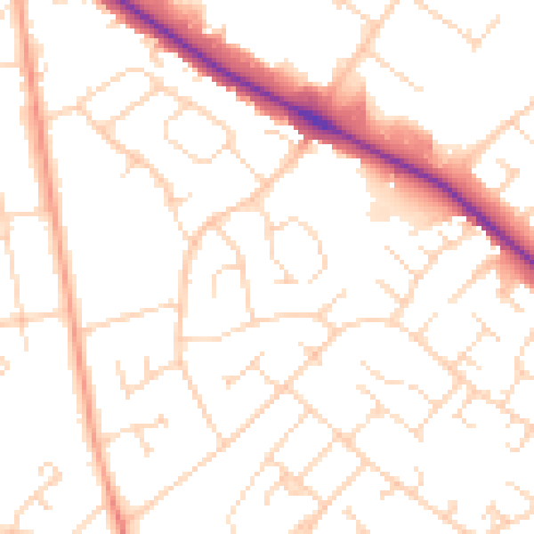
Daytime· 07:00 – 23:00
50.5dB

Night-time· 23:00 – 07:00
39.8dB