20 Hartside Gardens, Newcastle Upon Tyne, NE2 2JR
About 20 Hartside Gardens
20 Hartside Gardens is a three-bedroom semi-detached house in Newcastle Upon Tyne (NE2 2JR). It has a recorded floor area of 123 m² (around 1324 sq ft), construction records dating it to 1930-1949 and council tax band D. The latest certificate (September 2014) shows a C (score 69), just inside the C band. When first surveyed in July 2011 the rating was D, the property has climbed 1 band since. Between certificates, window efficiency went from Very Poor to Good; while lighting dropped from Average to Poor. The recommended improvements would push it to B (score 81). The latest certificate is from September 2014, so improvements made since then won't be reflected.
At 123 m² it's 18.3% larger than the typical home in the postcode (104 m² median across 17 EPCs). Its energy rating outperforms most of the postcode (better than 88% of similar EPCs). Across 2012–2021, sale prices on this property compounded at 5.8% per year. Today's modelled estimate of £452,000 is 15.2% above the 2021 sale price. On a £-per-square-foot basis, the last sale (£296/sq ft) was about 33.3% above the typical sold price in the postcode. Most recent transfer: April 2021 at £392,500. That sale was during the post-pandemic price surge, when transactions cleared materially above pre-2020 trend.
Know exactly what you're buying at 20 Hartside Gardens
Before you offer, see what the listing won't tell you, the true value, the red flags and the full history.
Already flagged here
Valuation
against the asking price
Risks
planning & flood
Sold prices
similar homes nearby
Trends
the local market
What this property has
Inside
- Bedrooms3
- Bathrooms1
Energy performance
20 Hartside Gardens's EPC is over a decade old — improvements since won't be reflected.
EPC Expired
This certificate is over 10 years old and is no longer valid.Expired 22 Sept 2024
EPC Rating
Property Improvements
Changes detected from historical EPC data
Heating controls upgraded for better temperature management
Windows upgraded, improving insulation
Planning history
20 Hartside Gardens has no planning applications on record.
Notable planning nearby
12applications of note in the surrounding area
We flagged 1 thing worth checking at 20 Hartside Gardens
Independent checks surfaced things a buyer would want to understand before offering. The report explains each one in full, with the underlying data and what to ask.
- Signs of HMO activity in the area
30-day money-back guarantee
Sales history & valuation
20 Hartside Gardens saw 3 transfers in just over a decade — high turnover for the postcode.
£452,000
Modelled from EPC, postcode comparables and a sale-price growth of 5.8% per year over 9 years.
£392,500
Growth on file: 5.8% per year over 9 years.
Sales timeline
8 April 2021Most recent
£392,500
+27.9%over 6 years12 February 2015
£307,000
+30.6%over 2 years5 March 2012
£235,000
Median price across the last 5 sales in NE2 2JR: £467,500 (2024–2021).
Nearby sales in NE2 2JR
19 Hartside Gardens, Newcastle Upon Tyne, NE2 2JR
Sold Nov 2024
£516,00013 Hartside Gardens, Newcastle Upon Tyne, NE2 2JR
Sold Aug 2023
£467,50021 Hartside Gardens, Newcastle Upon Tyne, NE2 2JR
Sold Feb 2023
£510,00023 Hartside Gardens, Newcastle Upon Tyne, NE2 2JR
Sold Feb 2023
£407,00012 Hartside Gardens, Newcastle Upon Tyne, NE2 2JR
Sold Dec 2021
£375,000
Everything we know about 20 Hartside Gardens, in one report
What it's really worth, what could be wrong, and the planning, sales and area data in full.
What we flagged
- Signs of HMO activity in the area

Versus other Hartside Gardens homes
On epc rating, 20 Hartside Gardens stands well clear of the street.
Price per m²
£3,191
Street avg £3,267
Floor Area
123 m²
Street avg 107 m²
Habitable Rooms
6 rooms
Street avg 5 rooms
CO₂ Emissions
4.4 t/year
Street avg 5.7 t/year
Similar properties nearby
1 Larkspur Terrace
NE2 2DT
1 Lily Crescent
NE2 2SP
1 Adderstone Court, Adderstone Crescent
NE2 2EA
1 Buston Terrace
NE2 2JL
1 Hartside Gardens
NE2 2JR
1 Lily Avenue
NE2 2SQ
1 Farquhar Street
NE2 2JJ
1 Jesmond Dene Terrace
NE2 2ET
The neighbourhood at a glance
Crime
5/mo
Steady year-on-year across the wider district.
Nearest stop
0.4 km
Cradlewell — bus stop.
Closest school
0.7 km
Jesmond Park Academy. 28 schools nearby.
Go deeper on the local area
The full report breaks down crime, transport links, schools and air quality in depth.
Road noise across the postcode
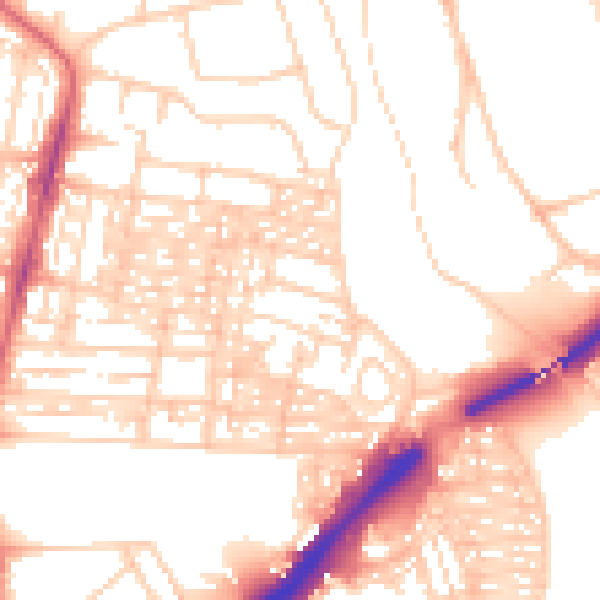
Daytime· 07:00 – 23:00
53.7dB

Night-time· 23:00 – 07:00
42.8dB