74 Barford Avenue, Bedford, MK42 0DT
About 74 Barford Avenue
74 Barford Avenue is a two-bedroom semi-detached house in Bedford (MK42 0DT). It has a recorded floor area of 55 m² (around 592 sq ft), construction records dating it to 1930-1949 and council tax band B. The latest certificate (November 2019) shows a D (score 64), on the cusp of jumping into the C band. The rating has held steady at D across 2 certificates since January 2009. Between certificates, hot-water efficiency dropped from Very Good to Good and main heating dropped from Very Good to Good. The recommended improvements would lift it to B (score 89), a 2-band jump.
Most recent transfer: May 2020 at £210,000. Across the public record there are 4 sales, relatively high churn for a single property. At 55 m² it's 21.4% smaller than the typical home in the postcode (70 m² median across 33 EPCs). It lags the bulk of the postcode on energy efficiency (less efficient than 82% of similar EPCs). Across 2002–2020, sale prices on this property compounded at 6.1% per year. Today's modelled estimate of £259,000 is 23.3% above the 2020 sale price. On a £-per-square-foot basis, the last sale (£355/sq ft) was about 113% above the typical sold price in the postcode.
Know exactly what you're buying at 74 Barford Avenue
Before you offer, see what the listing won't tell you, the true value, the red flags and the full history.
Already flagged here
Valuation
against the asking price
Risks
planning & flood
Sold prices
similar homes nearby
Trends
the local market
What this property has
Inside
- Bedrooms2
- Bathrooms1
Energy performance
Recommended upgrades on file would lift this property by multiple EPC bands.
EPC Rating
Planning history
74 Barford Avenue has no planning applications on record.
Notable planning nearby
8applications of note in the surrounding area
We flagged 2 things worth checking at 74 Barford Avenue
Independent checks surfaced things a buyer would want to understand before offering. The report explains each one in full, with the underlying data and what to ask.
- Signs of HMO activity in the area
- Larger development activity nearby
30-day money-back guarantee
Sales history & valuation
Latest sale on 74 Barford Avenue was the highest on Land Registry record across the postcode.
£259,000
Modelled from EPC, postcode comparables and a sale-price growth of 6.1% per year over 18 years.
£210,000
Growth on file: 6.1% per year over 18 years.
Sales timeline
13 May 2020Most recent
£210,000
+53.3%over 4 years27 May 2015
£137,000
+9.6%over 1 year7 February 2014
£125,000
+73.6%over 11 years7 March 2002
£72,000
Median price across the last 5 sales in MK42 0DT: £150,000 (2020–2010).
Nearby sales in MK42 0DT
Everything we know about 74 Barford Avenue, in one report
What it's really worth, what could be wrong, and the planning, sales and area data in full.
What we flagged
- Signs of HMO activity in the area
- Larger development activity nearby

Versus other Barford Avenue homes
74 Barford Avenue outperforms the street on price per m² by a wide margin.
Price per m²
£3,818
Street avg £1,908
Floor Area
55 m²
Street avg 68 m²
Habitable Rooms
3 rooms
Street avg 4 rooms
CO₂ Emissions
2.8 t/year
Street avg 2.4 t/year
Similar properties nearby
1 Acacia Road
MK42 0HT
1 Boscombe Lane, Shortstown
MK42 0EE
1 Alburgh Close
MK42 0HG
1 Beauvais Square, Shortstown
MK42 0GE
1 Brampton Close
MK42 0HD
1 Acorn Way
MK42 0QN
1 Brabazon Close, Shortstown
MK42 0FL
1 Atherstone Close, Shortstown
MK42 0GH
The neighbourhood at a glance
Rail-style transport is unusually close for this postcode.
Crime
6/mo
Steady year-on-year across the wider district.
Nearest stop
0.0 km
Collie Road — bus stop.
Closest school
0.6 km
King's Oak Primary School. 23 schools nearby.
Go deeper on the local area
The full report breaks down crime, transport links, schools and air quality in depth.
Road noise across the postcode
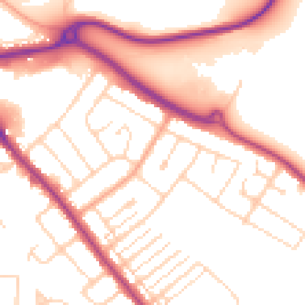
Daytime· 07:00 – 23:00
53.4dB

Night-time· 23:00 – 07:00
44.2dB