239 Cardington Road, Bedford, MK42 0DA
About 239 Cardington Road
239 Cardington Road is a three-bedroom semi-detached house in Bedford (MK42 0DA). It has a recorded floor area of 114 m² (around 1227 sq ft), construction records dating it to 1930-1949 and council tax band D. The latest certificate (November 2019) shows a D (score 60), on the cusp of jumping into the C band. When first surveyed in June 2009 the rating was E, the property has climbed 1 band since. Between certificates, wall efficiency went from Very Poor to Poor and lighting went from Average to Very Good; while hot-water efficiency dropped from Very Good to Good and main heating dropped from Very Good to Good. The recommended improvements would push it to C (score 78). Other recorded features include a conservatory and attached land beyond the plot. Our model identifies extension potential, subject to local planning policy.
Untraded for 17 years, with the last transfer in November 2009. That sale fell during the post-crash dip, which often skews comparisons against later neighbouring sales. Across 1997–2009, sale prices on this property compounded at 8.5% per year. Today's modelled estimate of £441,000 sits 57.5% above the 2009 sale of £280,000. On a £-per-square-foot basis, the last sale (£228/sq ft) was about 30.4% above the typical sold price in the postcode. At 114 m² it's 26.7% larger than the typical home in the postcode (90 m² median across 25 EPCs). 6 planning records sit against the property, 0 approved, 6 refused.
Know exactly what you're buying at 239 Cardington Road
Before you offer, see what the listing won't tell you, the true value, the red flags and the full history.
Already flagged here
Valuation
against the asking price
Risks
planning & flood
Sold prices
similar homes nearby
Trends
the local market
What this property has
Inside
- Bedrooms3
- Bathrooms1
- CloakroomYes
- EnsuiteYes
- ConservatoryYes
Outside
- GarageDouble, Detached
- LandYes
Building
- Extension potentialPossible
Energy performance
EPC Rating
Property Improvements
Changes detected from historical EPC data
Hot water efficiency decreased
Wall insulation improved
More low energy lighting installed
Planning history
A recent planning application at 239 Cardington Road was refused — worth checking the council file.
- Nov 2022New BuildOutlineIn report
Outline planning application for up to 9 dwellings and retention of existing dwelling with all matters reserved.
- Documents
- 24 docs on file
- Reference
- 22/01327/OUT
- Dec 2019
We flagged 3 things worth checking at 239 Cardington Road
Independent checks surfaced things a buyer would want to understand before offering. The report explains each one in full, with the underlying data and what to ask.
- Signs of HMO activity in the area
- Larger development activity nearby
- A planning decision worth checking
30-day money-back guarantee
Sales history & valuation
Sale price has at least doubled since 1997.
£441,000
Modelled from EPC, postcode comparables and a sale-price growth of 8.5% per year over 13 years.
£280,000
Growth on file: 8.5% per year over 13 years.
Sales timeline
27 November 2009Most recent
£280,000
+185.7%over 12 years14 January 1997
£98,000
Median price across the last 5 sales in MK42 0DA: £320,000 (2023–2021).
Nearby sales in MK42 0DA
Everything we know about 239 Cardington Road, in one report
What it's really worth, what could be wrong, and the planning, sales and area data in full.
What we flagged
- Signs of HMO activity in the area
- Larger development activity nearby
- A planning decision worth checking

Versus other Cardington Road homes
239 Cardington Road is notably below the street on co₂ emissions.
Price per m²
£2,456
Street avg £2,295
Floor Area
114 m²
Street avg 101 m²
Habitable Rooms
5 rooms
Street avg 5 rooms
CO₂ Emissions
5.6 t/year
Street avg 4.0 t/year
Similar properties nearby
1 Acorn Way
MK42 0QN
1 Brampton Close
MK42 0HD
1 Atherstone Close, Shortstown
MK42 0GH
1 Brabazon Close, Shortstown
MK42 0FL
1 Boscombe Lane, Shortstown
MK42 0EE
1 Acacia Road
MK42 0HT
1 Arnold Way, Shortstown
MK42 0FU
1 Alburgh Close
MK42 0HG
The neighbourhood at a glance
Crime
6/mo
Steady year-on-year across the wider district.
Nearest stop
0.0 km
Goodmayes Close — bus stop.
Closest school
0.6 km
King's Oak Primary School. 17 schools nearby.
Go deeper on the local area
The full report breaks down crime, transport links, schools and air quality in depth.
Road noise across the postcode
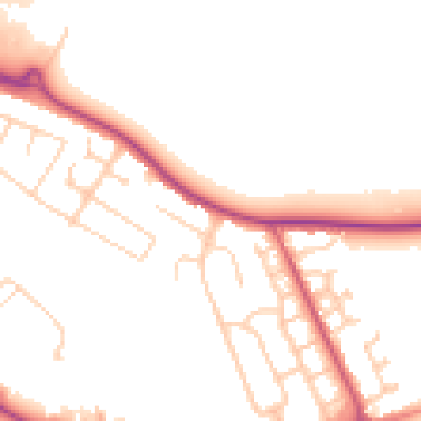
Daytime· 07:00 – 23:00
51.0dB
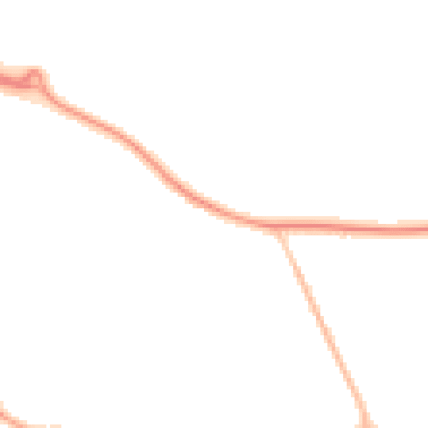
Night-time· 23:00 – 07:00
43.0dB