67 Cardington Road, Bedford, MK42 0BT
About 67 Cardington Road
67 Cardington Road is a four-bedroom detached house in Bedford (MK42 0BT). It has a recorded floor area of 132 m² (around 1421 sq ft), construction records dating it to 1930-1949 and council tax band D. The latest certificate (July 2024) shows a D (score 68), on the cusp of jumping into the C band. The recommended improvements would push it to C (score 78).
5 planning records sit against the property, 3 approved, 0 refused. Past consents include an extension, meaningful when judging how the property has evolved. At 132 m² it's 23.1% larger than the typical home in the postcode (107 m² median across 12 EPCs). Across 2001–2017, sale prices on this property compounded at 6.6% per year. Today's modelled estimate of £453,000 is 24.1% above the 2017 sale price. On a £-per-square-foot basis, the last sale (£257/sq ft) was about 50.3% above the typical sold price in the postcode. Last changed hands 9 years ago, in November 2017.
Know exactly what you're buying at 67 Cardington Road
Before you offer, see what the listing won't tell you, the true value, the red flags and the full history.
Already flagged here
Valuation
against the asking price
Risks
planning & flood
Sold prices
similar homes nearby
Trends
the local market
What this property has
Inside
- Bedrooms4
- Bathrooms1
Energy performance
EPC Rating
Planning history
67 Cardington Road has been extended on multiple sides of the property across separate planning applications.
- Aug 2025ConversionAmendmentIn report
Conversion of existing dwelling house (C3) into adult care home (C2) for 4 persons.
- Documents
- 11 docs on file
- Reference
- 25/01655/COU
- Sept 2023HMOAmendmentIn report
Change of Use from a Residential property (C3) to a HMO (C4)
Change of Use- Documents
- 8 docs on file
- Reference
- 23/02131/COU
We flagged 2 things worth checking at 67 Cardington Road
Independent checks surfaced things a buyer would want to understand before offering. The report explains each one in full, with the underlying data and what to ask.
- Signs of HMO activity in the area
- Larger development activity nearby
30-day money-back guarantee
Sales history & valuation
Sale price has at least doubled since 2001.
£453,000
Modelled from EPC, postcode comparables and a sale-price growth of 6.6% per year over 16 years.
£365,000
Growth on file: 6.6% per year over 16 years.
Sales timeline
24 November 2017Most recent
£365,000
+185.2%over 16 years28 June 2001
£128,000
Median price across the last 5 sales in MK42 0BT: £404,000 (2024–2019).
Nearby sales in MK42 0BT
Everything we know about 67 Cardington Road, in one report
What it's really worth, what could be wrong, and the planning, sales and area data in full.
What we flagged
- Signs of HMO activity in the area
- Larger development activity nearby

Versus other Cardington Road homes
67 Cardington Road outperforms the street on habitable rooms by a wide margin.
Price per m²
£2,765
Street avg £2,496
Floor Area
132 m²
Street avg 111 m²
Habitable Rooms
7 rooms
Street avg 5 rooms
CO₂ Emissions
4.7 t/year
Street avg 6.2 t/year
Similar properties nearby
1 Atherstone Close, Shortstown
MK42 0GH
1 Brabazon Close, Shortstown
MK42 0FL
1 Arnold Way, Shortstown
MK42 0FU
1 Acorn Way
MK42 0QN
1 Brampton Close
MK42 0HD
1 Boscombe Lane, Shortstown
MK42 0EE
1 Acacia Road
MK42 0HT
1 Blake S Boulevard, Shortstown
MK42 0ZL
The neighbourhood at a glance
Rail-style transport is unusually close for this postcode.
Crime
6/mo
Steady year-on-year across the wider district.
Nearest stop
0.1 km
Bedford Girls School — bus stop.
Closest school
0.5 km
Bedford Free School. 29 schools nearby.
Go deeper on the local area
The full report breaks down crime, transport links, schools and air quality in depth.
Road noise across the postcode
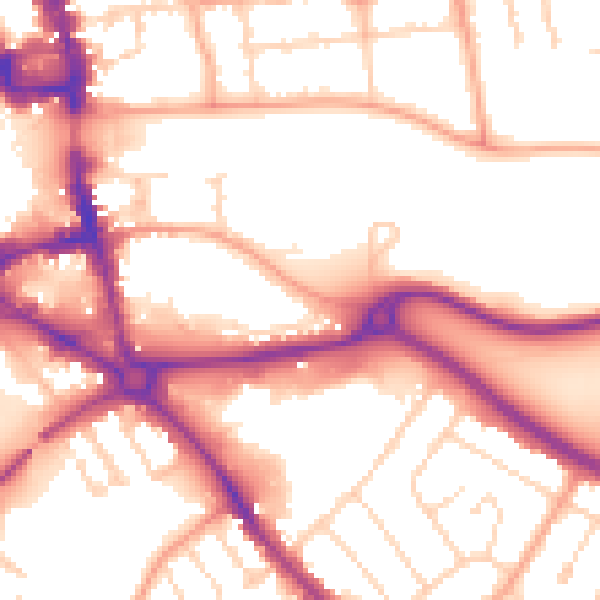
Daytime· 07:00 – 23:00
55.2dB

Night-time· 23:00 – 07:00
46.1dB