4 Jacobs Close, Stantonbury, Milton Keynes, MK14 6EJ
About 4 Jacobs Close
4 Jacobs Close is a detached house in Stantonbury, Milton Keynes, Milton Keynes (MK14 6EJ). It has a recorded floor area of 77 m² (around 829 sq ft), construction records dating it to 1991-1995 and council tax band B. The latest certificate (August 2016) returns an A (score 93), the top energy band on the EPC scale. When first surveyed in January 2010 the rating was C, the property has climbed 2 bands since. Between certificates, hot-water efficiency dropped from Very Good to Good and lighting dropped from Good to Average.
On energy efficiency it sits in the top 10% of properties in this postcode.
Know exactly what you're buying at 4 Jacobs Close
Before you offer, see what the listing won't tell you, the true value, the red flags and the full history.
Valuation
against the asking price
Risks
planning & flood
Sold prices
similar homes nearby
Trends
the local market
Energy performance
4 Jacobs Close ranks among the most efficient homes in the postcode for energy use.
EPC Rating
Property Improvements
Changes detected from historical EPC data
Hot water efficiency decreased
Planning history
4 Jacobs Close has no planning applications on record.
Notable planning nearby
2applications of note in the surrounding area
Sales history & valuation
4 Jacobs Close has no Land Registry sales on file, suggesting it has stayed in the same hands since registration began.
£257,000
Modelled from EPC, postcode comparables.
No sales recorded with HM Land Registry
That can mean the property has never traded since the registry began publishing in 1995, was a new build that hasn't been registered yet, or is held in the same hands long-term.
Everything we know about 4 Jacobs Close, in one report
What it's really worth, what could be wrong, and the planning, sales and area data in full.
- Am I paying too much?
- Is something wrong with it?
- Is the agent's story true?
- Will it hold its value?

Versus other Jacobs Close homes
On co₂ emissions, 4 Jacobs Close stands well clear of the street.
EPC Rating
93 (A)
Street avg 79 (C)
Floor Area
77 m²
Street avg 78 m²
CO₂ Emissions
0.8 t/year
Street avg 2.0 t/year
Habitable Rooms
3 rooms
Street avg 4 rooms
Similar properties nearby
1 Cheviot Gardens, Oakridge Park
MK14 6FZ
1 Burnet, Stantonbury
MK14 6AJ
1 Cable Grove, Oakridge Park
MK14 6FA
1 Barbers Mews, Neath Hill
MK14 6HS
1 Camlet Grove, Stantonbury Fields
MK14 6TD
1 Broad Arrow Close, Neath Hill
MK14 6JA
1 Dewsbury, Oakridge Park
MK14 6FW
1 Coopers Mews, Neath Hill
MK14 6HD
The neighbourhood at a glance
Crime
5/mo
Steady year-on-year across the wider district.
Nearest stop
0.3 km
Westhill — bus stop.
Closest school
0.2 km
Wood End Infant & Pre-School. 22 schools nearby.
Go deeper on the local area
The full report breaks down crime, transport links, schools and air quality in depth.
Road noise across the postcode
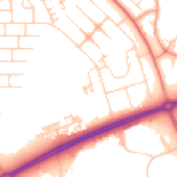
Daytime· 07:00 – 23:00
52.1dB

Night-time· 23:00 – 07:00
41.6dB