1 Bringewood Forge, Blakelands, Milton Keynes, MK14 5FJ
1 planning record
We're still gathering data on this property. Claim it to add details and complete this page.
About 1 Bringewood Forge
A plain-English summary derived from public records, EPC certificates, sold prices and local data.
1 Bringewood Forge is a property in Blakelands, Milton Keynes, Milton Keynes (MK14 5FJ).
One historical planning record sits against the property in 2011.
Energy performance
Every EPC certificate filed against this property — current rating, recorded improvements, and where there's headroom to reach a higher band.
No EPC on record
This property doesn't have an Energy Performance Certificate yet. An EPC is required to sell or let — and unlocks our automated valuation.
Planning history
Applications and permits filed against 1 Bringewood Forge, Blakelands, Milton Keynes, MK14 5FJ, sourced from the PlanIt planning register.
- Mar 2011FullIn report
Change of use from Sui Generis (formally car sales) to B1, B2 and B8
- Reference
- 11/00085/FUL
Similar properties nearby
A handful of close matches in the same postcode area, ranked by likeness on bedrooms, type and floor area.
£377k
1 Alder Court, Redhouse Park
MK14 5FL
1 bed1 bath
1 Alverton, Great Linford
MK14 5EF
1 Andrewes Croft, Great Linford
MK14 5HP
1 Annes Grove, Great Linford
MK14 5DR
1 Ashdown Close, Giffard Park
MK14 5PX
£247k
1 Barbury Court, Giffard Park
MK14 5PT
2 bed1 bath
£141k
1 Bekonscot Court, Giffard Park
MK14 5QS
1 bed1 bath
£250k
1 Bessemer Court, Blakelands
MK14 5JN
2 bed
The neighbourhood at a glance
A condensed read of the local area. Each tile links through to the full breakdown on the Milton Keynes district page.
Crime
5/mo
Steady year-on-year across the wider district.
Nearest stop
0.3 km
Knebworth Roundabout North — bus stop.
Closest school
0.3 km
Giffard Park Primary School. 16 schools nearby.
Road noise across the postcode
Modelled day and night-time noise levels around MK14 5FJ from Defra's strategic mapping. The pin marks this postcode's centroid.
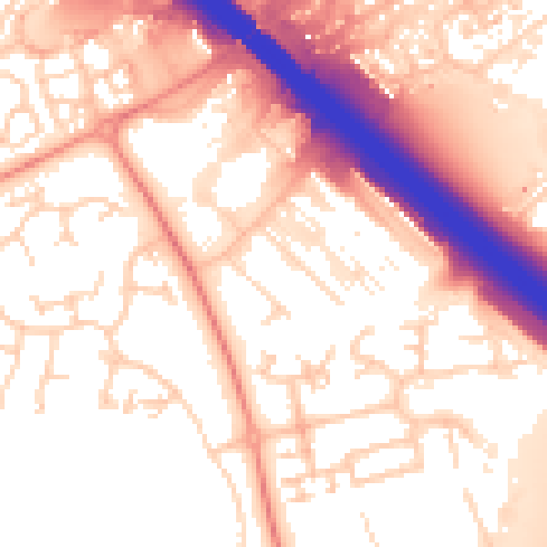
Daytime· 07:00 – 23:00
56.4dB

Night-time· 23:00 – 07:00
49.3dB
55 dB
60 dB
65 dB
70 dB
75 dB
80 dB
Defra Road Noise Strategic Mapping, Round 4Common questions
The questions buyers, sellers and homeowners most often ask about 1 Bringewood Forge, Blakelands, Milton Keynes, MK14 5FJ. Each answer is also embedded as structured data for search engines.